IMAGES TAKEN NEAR TO
Cowley Close, BIRMINGHAM, B36 9NJ
Introduction
This page details the photographs taken nearby to Cowley Close, B36 9NJ by members of the Geograph project.
The Geograph project started in 2005 with the aim of publishing, organising and preserving representative images for every square kilometre of Great Britain, Ireland and the Isle of Man.

There are currently over 7.5m images from over14,400 individuals and you can help contribute to the project by visiting https://www.geograph.org.uk
Image Map
Images are licensed for reuse under creativecommons.org/licenses/by-sa/2.0
Notes
- Clicking on the map will re-center to the selected point.
- The higher the marker number, the further away the image location is from the centre of the postcode.
Image Listing (14 Images Found)
Images are licensed for reuse under creativecommons.org/licenses/by-sa/2.0
Image
Details
Distance
1
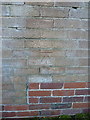
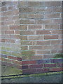
OS benchmark - Castle Bromwich, wall on Lanchester Way
A second OS cutmark on a wall on the south side of Lanchester Way, levelled in 1984 at 93.929m above Ordnance Datum Newlyn.
Image: © Richard Law
Taken: 15 Feb 2016
0.10 miles
2

Kingfisher Pub
This pub is on Rover Drive in Smithswood.
Image: © Carl Baker
Taken: 1 Nov 2006
0.10 miles
3

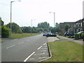
Sunbeam Close, Smith's Wood
Looking towards Rover Drive.
Image: © Richard Vince
Taken: 10 Mar 2018
0.10 miles
4
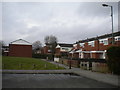
Houses off Sunbeam Close, Smith's Wood
Image: © Richard Vince
Taken: 10 Mar 2018
0.11 miles
5
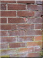
OS benchmark - Castle Bromwich, wall on Lanchester Way
The only remaining one of three that were cut into boundary walls in Image along a shortish stretch of Lanchester Way; this one was levelled in 1984 at 90.84m above Ordnance Datum Newlyn.
Image: © Richard Law
Taken: 14 Mar 2017
0.12 miles
9
OS benchmark - Castle Bromwich, Lanchester Way
An OS cutmark, made in 1984, on a wall opposite Lanchester Park. It was originally levelled at 101.683m above Ordnance Datum Newlyn.
Image: © Richard Law
Taken: 15 Feb 2016
0.19 miles
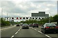
10
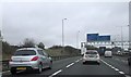
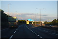
Approaching junction 4a of M6 southbound
Image: © John Firth
Taken: 29 Oct 2014
0.19 miles