IMAGES TAKEN NEAR TO
Reliant Close, BIRMINGHAM, B36 9NG
Introduction
This page details the photographs taken nearby to Reliant Close, B36 9NG by members of the Geograph project.
The Geograph project started in 2005 with the aim of publishing, organising and preserving representative images for every square kilometre of Great Britain, Ireland and the Isle of Man.

There are currently over 7.5m images from over14,400 individuals and you can help contribute to the project by visiting https://www.geograph.org.uk
Image Map
Images are licensed for reuse under creativecommons.org/licenses/by-sa/2.0
Notes
- Clicking on the map will re-center to the selected point.
- The higher the marker number, the further away the image location is from the centre of the postcode.
Image Listing (10 Images Found)
Images are licensed for reuse under creativecommons.org/licenses/by-sa/2.0
Image
Details
Distance
1
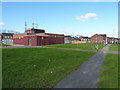
Electrical sub-station on Lanchester Way
Power distribution facility for the extensive housing developments of Castle Bromwich.
Image: © Richard Law
Taken: 15 Feb 2016
0.04 miles
2
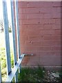
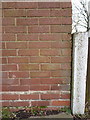
OS benchmark - Castle Bromwich, electrical substation on Lanchester Way
An OS cutmark on the north wall of the substation on the west side of Lanchester Way; originally levelled in 1984 at 106.698m above Ordnance Datum Newlyn.
Image: © Richard Law
Taken: 15 Feb 2016
0.04 miles
3
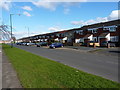
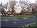
Houses on Lanchester Way
1970s terraces of housing in the Castle Bromwich area. Many of the roads on this estate are named in memory of the once-extensive UK car industry, with Singer Croft, Hillman Grove, Morris Croft and Austin Croft leading off Lanchester Way, and Rover Drive, Vauxhall Crescent, Humber Grove, Riley Drive and Daimler Grove amongst others just to the east.
Image: © Richard Law
Taken: 15 Feb 2016
0.09 miles
4
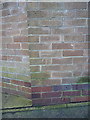
OS benchmark - Castle Bromwich, Lanchester Way
An OS cutmark, made in 1984, on a wall opposite Lanchester Park. It was originally levelled at 101.683m above Ordnance Datum Newlyn.
Image: © Richard Law
Taken: 15 Feb 2016
0.16 miles
5
St. Clements Church
Church of England denomination, on Green Lane, corner of Blandford Avenue
Image: © Michael Westley
Taken: 18 Feb 2012
0.18 miles
6
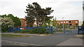
Park Hall Academy
Water Orton Road, Castle Bromwich
http://www.parkhallschool.org.uk/
Image: © Michael Westley
Taken: 1 May 2011
0.22 miles
7
OS benchmark - Kingshurst, Castle Bromwich Infant School
An OS cutmark on one of the original brick buildings at the school; levelled in 1965 at 105.408m above Ordnance Datum Newlyn.
Image: © Richard Law
Taken: 20 Feb 2015
0.22 miles
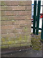
9
OS benchmark - Kingshurst, 168 Alvis Walk
An OS cutmark on the front 'porch' of 168 Alvis Walk; originally levelled in 1984 at 103.688m above Ordnance Datum Newlyn.
Image: © Richard Law
Taken: 20 Feb 2015
0.23 miles
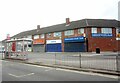
10
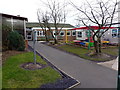
Castle Bromwich Infant & Nursery School
Newish buildings now used as part of the school; there are older, brick-built classrooms and offices just off-shot to the left of this photo. The original part of the school would date from the early 1960s.
Image: © Richard Law
Taken: 20 Feb 2015
0.24 miles