IMAGES TAKEN NEAR TO
Usk Way, BIRMINGHAM, B36 0TN
Introduction
This page details the photographs taken nearby to Usk Way, B36 0TN by members of the Geograph project.
The Geograph project started in 2005 with the aim of publishing, organising and preserving representative images for every square kilometre of Great Britain, Ireland and the Isle of Man.

There are currently over 7.5m images from over14,400 individuals and you can help contribute to the project by visiting https://www.geograph.org.uk
Image Map
Images are licensed for reuse under creativecommons.org/licenses/by-sa/2.0
Notes
- Clicking on the map will re-center to the selected point.
- The higher the marker number, the further away the image location is from the centre of the postcode.
Image Listing (11 Images Found)
Images are licensed for reuse under creativecommons.org/licenses/by-sa/2.0
Image
Details
Distance
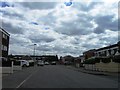
3
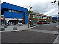
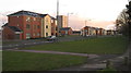
Newly-built town centre facilities in Kingshurst
Not yet marked on the maps, this area of Kingshurst or Smith's Wood has seen extensive redevelopment in recent times.
Image: © Richard Law
Taken: 24 Sep 2015
0.15 miles
4

OS rivet & benchmark - Kingshurst, Tamar Drive
An OS rivet, with locating arrow, on a wall on the west side of Tamar Drive; originally levelled in 1984 at 95.447m above Ordnance Datum Newlyn.
Image: © Richard Law
Taken: 20 Feb 2015
0.16 miles
5
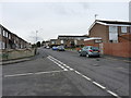
Tamar Drive, Kingshurst
An extensive development of houses, apparently dating from the late '70s or early '80s.
Image: © Richard Law
Taken: 20 Feb 2015
0.17 miles
6
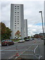
Clare House, Kingshurst
The other one of the pair Image which lie on Burton Way.
Image: © Richard Law
Taken: 24 Sep 2015
0.18 miles
7
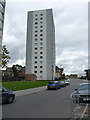
Pembroke House, Kingshurst
One of a pair of identical tower blocks; Clare House is its twin beyond.
Image: © Richard Law
Taken: 24 Sep 2015
0.19 miles
9
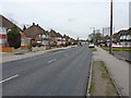
Buckingham Road, Kingshurst
1950s semis along Buckingham Road, looking towards the (as-yet unphotographed) tower blocks in Image
Image: © Richard Law
Taken: 20 Feb 2015
0.22 miles
