IMAGES TAKEN NEAR TO
Swallow Avenue, BIRMINGHAM, B36 0RH
Introduction
This page details the photographs taken nearby to Swallow Avenue, B36 0RH by members of the Geograph project.
The Geograph project started in 2005 with the aim of publishing, organising and preserving representative images for every square kilometre of Great Britain, Ireland and the Isle of Man.

There are currently over 7.5m images from over14,400 individuals and you can help contribute to the project by visiting https://www.geograph.org.uk
Image Map
Images are licensed for reuse under creativecommons.org/licenses/by-sa/2.0
Notes
- Clicking on the map will re-center to the selected point.
- The higher the marker number, the further away the image location is from the centre of the postcode.
Image Listing (26 Images Found)
Images are licensed for reuse under creativecommons.org/licenses/by-sa/2.0
Image
Details
Distance
1
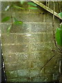
OS benchmark - Smith's Wood, building on Auckland Drive
An OS cutmark on the north wall of a small wheely-bin store on Auckland Drive; originally levelled in 1984 at 91.067m above Ordnance Datum Newlyn.
Image: © Richard Law
Taken: 24 Sep 2015
0.05 miles
3
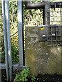
OS benchmark - Smith's Wood, M6 pedestrian overbridge
An OS cutmark on the parapet wall of the overbridge; originally levelled in 1984 at 94.179m above Ordnance Datum Newlyn.
Image: © Richard Law
Taken: 24 Sep 2015
0.10 miles
4
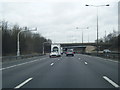
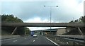
M6 North, bridges at junction 4a
The bridge in the foreground carries a public footpath. The view from it is Image The bridge beyond joins M6 northbound from the southbound M42 and M6 Toll, south of Water Orton. Sorry about the thumb.
Image: © Robin Stott
Taken: 25 Sep 2010
0.11 miles
6
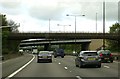
A footbridge over the M6
The footbridge connects Castle Bromwich and Water Orton.
Image: © Steve Daniels
Taken: 9 May 2015
0.11 miles
7
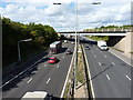
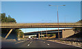
M6 motorway
M6 north and southbound carriageways from the (first) overbridge seen in Image
Image: © Richard Law
Taken: 24 Sep 2015
0.13 miles
8
Red Wing Walk, Smith's Wood
Looking towards Swift Close.
Image: © Richard Vince
Taken: 10 Mar 2018
0.13 miles
9
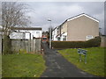
Footpath to Auckland Drive, Smith's Wood
Seen from Red Wing Walk. The houses on this path are numbered as part of Auckland Drive (the road at the far end of the path), hence the street sign.
Image: © Richard Vince
Taken: 10 Mar 2018
0.13 miles
10
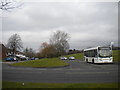
Lanchester Way bus turning circle, Smith's Wood
At the east end of Lanchester Way, where it meets Auckland Drive (foreground). Route 53, a wonderfully meandering route from Erdington, terminates here; igo KX08 UXU, a short wheelbase Alexander Dennis Enviro 200, is laying over between journeys on that service. When Travel West Midlands routes 95 and 99 terminated here, they showed "Chelmsley Wood North" as their destination; the 53, somewhat more appropriately, shows "Smith's Wood".
Image: © Richard Vince
Taken: 10 Mar 2018
0.15 miles