IMAGES TAKEN NEAR TO
Greenfinch Road, BIRMINGHAM, B36 0QY
Introduction
This page details the photographs taken nearby to Greenfinch Road, B36 0QY by members of the Geograph project.
The Geograph project started in 2005 with the aim of publishing, organising and preserving representative images for every square kilometre of Great Britain, Ireland and the Isle of Man.

There are currently over 7.5m images from over14,400 individuals and you can help contribute to the project by visiting https://www.geograph.org.uk
Image Map
Images are licensed for reuse under creativecommons.org/licenses/by-sa/2.0
Notes
- Clicking on the map will re-center to the selected point.
- The higher the marker number, the further away the image location is from the centre of the postcode.
Image Listing (11 Images Found)
Images are licensed for reuse under creativecommons.org/licenses/by-sa/2.0
Image
Details
Distance
2
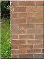
OS benchmark - Kingshurst, building on Arran Way
An OS cutmark on the corner of a rather austere-looking office building on Arran Way; originally levelled at 84.794m above Ordnance Datum Newlyn.
Image: © Richard Law
Taken: 24 Sep 2015
0.12 miles
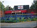
4

The Local Pub
Viewed from Auckland Drive.
Image: © Carl Baker
Taken: 12 Sep 2006
0.14 miles
5
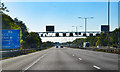
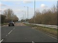
M6 south of Junction 4A
17 miles to Coventry.
Image: © J.Hannan-Briggs
Taken: 26 Sep 2015
0.14 miles
6
Smith's Wood
Once a small, isolated copse in the countryside near Burton's Farm, this is now surrounded by the housing estates of northeast Solihull, and has Windward Way slicing right through the middle of it. Such is progress.
Image: © Richard Law
Taken: 24 Sep 2015
0.19 miles
7

OS benchmark - Kingshurst, 15 Ellice Drive
An OS cutmark dating from 1984 on the wall of no 15 Ellice Drive; originally levelled at 85.865m above Ordnance Datum Newlyn.
Image: © Richard Law
Taken: 24 Sep 2015
0.19 miles
8
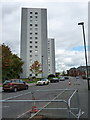
Clare House, Kingshurst
The other one of the pair Image which lie on Burton Way.
Image: © Richard Law
Taken: 24 Sep 2015
0.23 miles
9
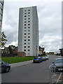
Pembroke House, Kingshurst
One of a pair of identical tower blocks; Clare House is its twin beyond.
Image: © Richard Law
Taken: 24 Sep 2015
0.23 miles
10
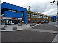
Newly-built town centre facilities in Kingshurst
Not yet marked on the maps, this area of Kingshurst or Smith's Wood has seen extensive redevelopment in recent times.
Image: © Richard Law
Taken: 24 Sep 2015
0.24 miles