IMAGES TAKEN NEAR TO
Javelin Avenue, BIRMINGHAM, B35 7LW
Introduction
This page details the photographs taken nearby to Javelin Avenue, B35 7LW by members of the Geograph project.
The Geograph project started in 2005 with the aim of publishing, organising and preserving representative images for every square kilometre of Great Britain, Ireland and the Isle of Man.

There are currently over 7.5m images from over14,400 individuals and you can help contribute to the project by visiting https://www.geograph.org.uk
Image Map
Images are licensed for reuse under creativecommons.org/licenses/by-sa/2.0
Notes
- Clicking on the map will re-center to the selected point.
- The higher the marker number, the further away the image location is from the centre of the postcode.
Image Listing (17 Images Found)
Images are licensed for reuse under creativecommons.org/licenses/by-sa/2.0
Image
Details
Distance
1

New Housing, Castle Vale
Looking across grass area and play area towards recent new housing.
Image: © Michael Westley
Taken: 19 Feb 2010
0.04 miles
2

Housing, Javelin Way, Castle Vale
View along footpath beside housing on Javelin Way.
Image: © Michael Westley
Taken: 20 Feb 2010
0.05 miles
3

Skate Park and Play Area, Castle Vale
Next to football ground car park, the play area and grass run alongside the new housing on Castle Vale.
Image: © Michael Westley
Taken: 19 Feb 2010
0.07 miles
4

Javelin Way housing Castle Vale
View from path beside stream and railway line on Castle Vale housing estate. New housing in background is Javelin Way.
Image: © Michael Westley
Taken: 20 Feb 2010
0.07 miles
5

New Housing, Castle Vale
Housing on Kestrel Close, bordering on grass area beside football ground.
Image: © Michael Westley
Taken: 19 Feb 2010
0.09 miles
6
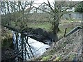
Stream and housing estate, Castle Vale
View from railway bridge Image] of path behind houses / Blenheim Way.
Image: © Michael Westley
Taken: 20 Feb 2010
0.13 miles
7

Housing and playarea, Castle Vale
Open space on Castle Vale housing estate.
Image: © Michael Westley
Taken: 20 Feb 2010
0.14 miles
8
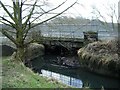
Railway bridge, Castle Vale
Birmingham - Water Orton railway line passes over stream near Recycling Centre at Castle Vale. Photo taken from path that runs behind newest housing estate (Belheim Way / Lancaster Drive).
Image: © Michael Westley
Taken: 20 Feb 2010
0.14 miles
9
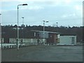
Paget Rangers Football Ground, Castle Vale
Local football club on vale. The woods immediately behind the buildings is Parkhill Wood (a site of interest), and behind that (though you wouldn't know it - no noise) is the M6 motorway east of junction 5.
Image: © Michael Westley
Taken: 19 Feb 2010
0.14 miles
