IMAGES TAKEN NEAR TO
St. Athan Croft, BIRMINGHAM, B35 7LR
Introduction
This page details the photographs taken nearby to St. Athan Croft, B35 7LR by members of the Geograph project.
The Geograph project started in 2005 with the aim of publishing, organising and preserving representative images for every square kilometre of Great Britain, Ireland and the Isle of Man.

There are currently over 7.5m images from over14,400 individuals and you can help contribute to the project by visiting https://www.geograph.org.uk
Image Map
Images are licensed for reuse under creativecommons.org/licenses/by-sa/2.0
Notes
- Clicking on the map will re-center to the selected point.
- The higher the marker number, the further away the image location is from the centre of the postcode.
Image Listing (15 Images Found)
Images are licensed for reuse under creativecommons.org/licenses/by-sa/2.0
Image
Details
Distance
1

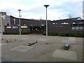
Castle Vale School and Astral Centre
Entrance to school and community centre on Castle Vale estate (off Farnborough Road).
Image: © Michael Westley
Taken: 19 Feb 2010
0.09 miles
2
St Cuthbert's church, Castle Vale
One of two modern churches in this square, the other being Image St Cuthbert's is rather less shy about its identity.
Image: © Richard Law
Taken: 11 Mar 2020
0.13 miles
3

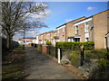
New Housing, Castle Vale
Housing on Kestrel Close, bordering on grass area beside football ground.
Image: © Michael Westley
Taken: 19 Feb 2010
0.15 miles
4

Corbett House, Castle Vale
Located on the corner of Tangmere Drive and High Street. The ground floor has shop units, the upper floors appear to be residential
Image: © Richard Law
Taken: 11 Mar 2020
0.16 miles
5
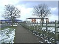
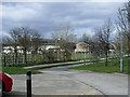
Footpath west of Valencia Croft, Castle Vale
Looking towards Turnhouse Road.
Image: © Richard Vince
Taken: 2 Mar 2019
0.17 miles
6
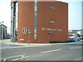
Castle Vale Police Station
Castle Vale has been subjected to extensive modernisation and improvement.
The Police Station is a clear example of this.
Image: © Mark Walton
Taken: 28 Mar 2007
0.18 miles
7
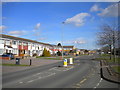
Castle Vale, New Housing
View along Farnborough Road east towards flats / housing Image
Blue roofed building on left is Bettaware factory that backs onto Park Lane.
Image: © Michael Westley
Taken: 19 Feb 2010
0.19 miles
8

Bus on Turnhouse Road, Castle Vale
National Express West Midlands 4533, a Volvo B7TL/Wright Eclipse Gemini, lays over at the bus stand on Turnhouse Road between journeys on route 67, the route linking Castle Vale estate with Birmingham city centre. The 67 formerly terminated in a turning circle at Reed Square, but since the redevelopment of the district centre it has turned by circumnavigating the centre, laying over here between the set down and pick up points. For many years, the 67 was operated using articulated buses (hence the provision of the very long layby here), but reverted to double decker operation a few years ago.
Image: © Richard Vince
Taken: 2 Mar 2019
0.19 miles
10
Estate Paddock
Area cordened off for grazing horses. Small car park behind new retirement home on Farnborough Road.
Image: © Michael Westley
Taken: 27 Mar 2010
0.19 miles