IMAGES TAKEN NEAR TO
Prestwick Road, BIRMINGHAM, B35 6PF
Introduction
This page details the photographs taken nearby to Prestwick Road, B35 6PF by members of the Geograph project.
The Geograph project started in 2005 with the aim of publishing, organising and preserving representative images for every square kilometre of Great Britain, Ireland and the Isle of Man.

There are currently over 7.5m images from over14,400 individuals and you can help contribute to the project by visiting https://www.geograph.org.uk
Image Map
Images are licensed for reuse under creativecommons.org/licenses/by-sa/2.0
Notes
- Clicking on the map will re-center to the selected point.
- The higher the marker number, the further away the image location is from the centre of the postcode.
Image Listing (35 Images Found)
Images are licensed for reuse under creativecommons.org/licenses/by-sa/2.0
Image
Details
Distance
1

St Gerard's RC church in Castle Vale
The rather featureless modern church lies at the northeasterly end of Yatesbury Avenue.
Image: © Richard Law
Taken: 11 Mar 2020
0.13 miles
2
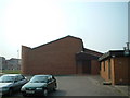
St Gerard's Catholic Church
A modern Church with security in mind, it has no windows. Without the sign (not readable in the photograph) it would be difficult to identify the building as a Church.
Image: © Mark Walton
Taken: 28 Mar 2007
0.13 miles
3
Birmingham and Fazeley Canal near Minworth, Birmingham
Image: © Roger D Kidd
Taken: 29 Aug 2012
0.19 miles
4

Bus on Turnhouse Road, Castle Vale
National Express West Midlands 4533, a Volvo B7TL/Wright Eclipse Gemini, lays over at the bus stand on Turnhouse Road between journeys on route 67, the route linking Castle Vale estate with Birmingham city centre. The 67 formerly terminated in a turning circle at Reed Square, but since the redevelopment of the district centre it has turned by circumnavigating the centre, laying over here between the set down and pick up points. For many years, the 67 was operated using articulated buses (hence the provision of the very long layby here), but reverted to double decker operation a few years ago.
Image: © Richard Vince
Taken: 2 Mar 2019
0.20 miles
5

Birmingham & Fazeley Canal: Forge Lane Bridge
Although this bridge is modern old Ordnance Survey maps show that there has been a bridge crossing of the canal here since at least the 1880s.
Image: © Nigel Cox
Taken: 8 Sep 2012
0.20 miles
6
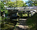
Forge Lane Bridge in Minworth
Crossing the Birmingham & Fazeley Canal.
Image: © Mat Fascione
Taken: 27 Sep 2015
0.20 miles
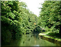
7

Birmingham & Fazeley Canal
Looking towards Minworth with the bridge carrying the Sutton Park line.
Image: © David Stowell
Taken: 26 Apr 2007
0.20 miles
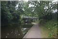
8

Forge Lane Bridge near Minworth, Birmingham
Forge Lane links a large industrial estate to the A38 Kingsbury Road (off to the right).
Image: © Roger D Kidd
Taken: 29 Aug 2012
0.20 miles
9
Birmingham & Fazeley Canal at Forge Lane Bridge
Image: © Ian S
Taken: 24 Jul 2021
0.21 miles
10

Forge Lane Bridge, Birmingham and Fazeley Canal
Towpath below Forge Lane, Minworth, looking south-west in direction of Chester Road.
Image: © Michael Westley
Taken: 13 Mar 2010
0.21 miles