IMAGES TAKEN NEAR TO
Hawkinge Drive, BIRMINGHAM, B35 6BP
Introduction
This page details the photographs taken nearby to Hawkinge Drive, B35 6BP by members of the Geograph project.
The Geograph project started in 2005 with the aim of publishing, organising and preserving representative images for every square kilometre of Great Britain, Ireland and the Isle of Man.

There are currently over 7.5m images from over14,400 individuals and you can help contribute to the project by visiting https://www.geograph.org.uk
Image Map
Images are licensed for reuse under creativecommons.org/licenses/by-sa/2.0
Notes
- Clicking on the map will re-center to the selected point.
- The higher the marker number, the further away the image location is from the centre of the postcode.
Image Listing (51 Images Found)
Images are licensed for reuse under creativecommons.org/licenses/by-sa/2.0
Image
Details
Distance
1
Northern road junction to Castle vale
This photograph was taken from the central reservation on the A38 shows the entry road to the Castle Vale estate
Image: © Mark Walton
Taken: 28 Mar 2007
0.08 miles
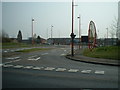
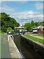
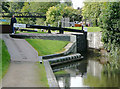
2
Lock Keeper's Cottage
Minworth Top Lock on the Birmingham and Fazeley Canal.
Image: © Andrew Abbott
Taken: 15 Sep 2022
0.13 miles
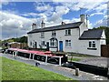
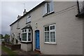
3
BCN houses at Minworth Top Lock
On the Birmingham & Fazeley canal, which is part of the BCN [Birmingham Canal Navigations]. All BCN houses are numbered, and two of the houses are numbered 250 and 251. These numbers do not refer to a street, just to the list of BCN houses.
Image: © Christine Johnstone
Taken: 9 May 2022
0.13 miles
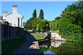
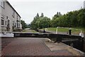
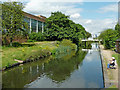
5
Minworth Top Lock near Castle Vale, Birmingham
Looking south-east towards Birmingham, the Minworth flight of three locks provides a rise (or fall) of 16ft 8in (just over five metres). Shown here is the top lock. They are quite widely spaced yet are still treated as a flight. Birmingham and Fazeley Canal.
Image: © Roger Kidd
Taken: 20 Aug 2012
0.14 miles
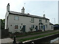
6
Former lockkeepers' cottages, Birmingham & Fazeley Canal
Image: © Ian S
Taken: 24 Jul 2021
0.14 miles
8
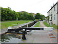
Minworth Top Lock near Castle Vale, Birmingham
Birmingham and Fazeley Canal.
The widely spaced Minworth Three locks provide a fall in water level of 16ft 8in (about five metres).
Image: © Roger D Kidd
Taken: 29 Aug 2012
0.14 miles
9
Birmingham and Fazeley Canal at Minworth Top Lock, Birmingham
There are three well spaced locks at Minworth, changing the water level by a total of 16ft 8in (about 5.1 metres). The A38 road runs close by the canal for about four miles, and alongside it here.
Image: © Roger D Kidd
Taken: 10 Sep 2008
0.14 miles
10
Birmingham and Fazeley Canal near Castle Vale, Birmingham
Looking north-east towards Curdworth and Fazeley. The Cincinatti factory on the left closed (c 2009?) and has been demolished since this 2012 image was obtained, and the land used for housing. The footbridge has also gone.
Image: © Roger Kidd
Taken: 20 Aug 2012
0.14 miles