IMAGES TAKEN NEAR TO
Audley Road, BIRMINGHAM, B33 9DP
Introduction
This page details the photographs taken nearby to Audley Road, B33 9DP by members of the Geograph project.
The Geograph project started in 2005 with the aim of publishing, organising and preserving representative images for every square kilometre of Great Britain, Ireland and the Isle of Man.

There are currently over 7.5m images from over14,400 individuals and you can help contribute to the project by visiting https://www.geograph.org.uk
Image Map
Images are licensed for reuse under creativecommons.org/licenses/by-sa/2.0
Notes
- Clicking on the map will re-center to the selected point.
- The higher the marker number, the further away the image location is from the centre of the postcode.
Image Listing (6 Images Found)
Images are licensed for reuse under creativecommons.org/licenses/by-sa/2.0
Image
Details
Distance
2
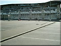
Matalan after fire
Side view of Matalan on Stechford retail park after fire gutting shop.
Image: © Carl Baker
Taken: 4 Apr 2006
0.14 miles

4
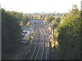
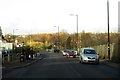
Approaching Stechford by rail
View from Hill House Lane footbridge, the approaches to Stechford, looking towards the city. The platform of the station can just be seen beneath the road bridge (A4040).
The right-hand track (beyond the points) routes trains up the largely freight line that runs up to Aston without travelling through the city centre.
Image: © Michael Westley
Taken: 25 Oct 2010
0.24 miles