IMAGES TAKEN NEAR TO
Yardley Fields Road, BIRMINGHAM, B33 8TX
Introduction
This page details the photographs taken nearby to Yardley Fields Road, B33 8TX by members of the Geograph project.
The Geograph project started in 2005 with the aim of publishing, organising and preserving representative images for every square kilometre of Great Britain, Ireland and the Isle of Man.

There are currently over 7.5m images from over14,400 individuals and you can help contribute to the project by visiting https://www.geograph.org.uk
Image Map
Images are licensed for reuse under creativecommons.org/licenses/by-sa/2.0
Notes
- Clicking on the map will re-center to the selected point.
- The higher the marker number, the further away the image location is from the centre of the postcode.
Image Listing (28 Images Found)
Images are licensed for reuse under creativecommons.org/licenses/by-sa/2.0
Image
Details
Distance
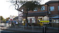
1
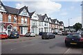
Modern flats - Yardley Fields Road
Flats at top end of road, near junction with Stuarts Road and war memorial Image]
Image: © Michael Westley
Taken: 25 Oct 2010
0.06 miles
2
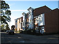
Mini roundabout at Five Ways
The building work seen on the right of Image is now complete, and has resulted in the rather striking set of apartments here on the far side of the junction.
Image: © Richard Law
Taken: 27 Feb 2015
0.08 miles
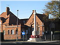
3
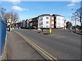
Stechford War Memorial and Five Ways road junction
Image: © Nigel Thompson
Taken: 30 Jun 2021
0.08 miles
4
OS benchmark - Five Ways, school entrance
An OS cutmark on the wall at the entrance doorway to the junior school beside the Five Ways junction; originally levelled at 113.124m above Ordnance Datum Newlyn.
Image: © Richard Law
Taken: 27 Feb 2015
0.08 miles
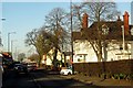
5
Corpus Christi Catholic Primary School
On Lyttleton Road, Stechford
Image: © Michael Westley
Taken: 25 Oct 2010
0.09 miles
6
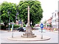
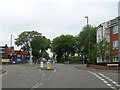
Stechford Five Ways
The Stone Cross war memorial. Away from the A4040, Stechford is a pleasant, mature suburb.
Image: © Adrian Bailey
Taken: 29 Jun 2005
0.09 miles
7

OS benchmark - Stechford, 311 Station Road
An OS cutmark on the NE face of no 311 (which appears currently to be unoccupied). The mark was originally levelled at 109.935m above Ordnance Datum Newlyn.
Image: © Richard Law
Taken: 27 Feb 2015
0.10 miles
9
Stechford Primary School and Nursery
Behind war memorial, on junction of Richmond Road and Albert Road, at 'Five Ways' Stechford - see also Image]
Image: © Michael Westley
Taken: 25 Oct 2010
0.11 miles