IMAGES TAKEN NEAR TO
Church Road, BIRMINGHAM, B33 8NY
Introduction
This page details the photographs taken nearby to Church Road, B33 8NY by members of the Geograph project.
The Geograph project started in 2005 with the aim of publishing, organising and preserving representative images for every square kilometre of Great Britain, Ireland and the Isle of Man.

There are currently over 7.5m images from over14,400 individuals and you can help contribute to the project by visiting https://www.geograph.org.uk
Image Map
Images are licensed for reuse under creativecommons.org/licenses/by-sa/2.0
Notes
- Clicking on the map will re-center to the selected point.
- The higher the marker number, the further away the image location is from the centre of the postcode.
Image Listing (34 Images Found)
Images are licensed for reuse under creativecommons.org/licenses/by-sa/2.0
Image
Details
Distance
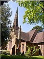
1
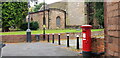
St Edburgha's Church and Postbox
The conservation area around St Edburgha's Church still feels like a village and tranquil, despite the area having long since been swallowed up by and absorbed into Birmingham.
Image: © Paul Collins
Taken: 17 Sep 2023
0.03 miles
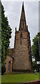
2
North Elevation, St Edburgha's Church
St Edburgha's Church is grade one listed and of Saxon foundation. Much mediaeval masonry survives.
Image: © Paul Collins
Taken: 17 Sep 2023
0.04 miles
3

The Bells, St Edburgha's Church
St Edburgha's Church is grade one listed and of Saxon foundation. Much mediaeval masonry survives. The tower was built in the 1460s. The bells and frame were installed in 1950, the bells having been recast from older bells.
Image: © Paul Collins
Taken: 17 Sep 2023
0.04 miles
4

Tower Roof, St Edburgha's Church
St Edburgha's Church is grade one listed and of Saxon foundation. Much mediaeval masonry survives. The tower and spire, just visible to the left, were built in the 1460s.
Image: © Paul Collins
Taken: 17 Sep 2023
0.04 miles
5
St Edburgha's Church Tower
St Edburgha's Church is grade one listed and of Saxon foundation. Much mediaeval masonry survives. The tower and spire were built in the 1460s.
Image: © Paul Collins
Taken: 17 Sep 2023
0.04 miles
6
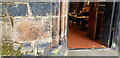
Benchmark, St Edburgha''s Church
This cut benchmark is located by the main west door of the church. I haven't checked but I surmise it is an old benchmark as they tend to be larger and higher off the ground than 'newer' ones. The church is grade one listed and of ancient foundation. Much mediaeval masonry survives.
Image: © Paul Collins
Taken: 17 Sep 2023
0.04 miles
7

Inside the Spire, St Edburgha's Church
St Edburgha's Church is of ancient foundation and is grade I listed. It is largely mediaeval and escaped too much Victorian 'improvement'. The spire dates from 1461 although it was partly rebuilt in the 19th century. Although the photo isn't great quality I thought it merited inclusion.
Image: © Paul Collins
Taken: 17 Sep 2023
0.04 miles
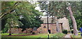
8

Old Houses in Church Road
The conservation area around St Edburgha's Church still feels like a village and tranquil, despite the area having long since been swallowed up by and absorbed into Birmingham.
Image: © Paul Collins
Taken: 17 Sep 2023
0.04 miles
9
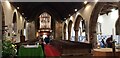
Nave, St Edburgha's Church
The church is grade one listed and of Saxon foundation. Much mediaeval masonry survives. The nave, and tower beyond, are largely 14th and 15th centuries.
Image: © Paul Collins
Taken: 17 Sep 2023
0.04 miles