IMAGES TAKEN NEAR TO
Mackadown Lane, BIRMINGHAM, B33 0JJ
Introduction
This page details the photographs taken nearby to Mackadown Lane, B33 0JJ by members of the Geograph project.
The Geograph project started in 2005 with the aim of publishing, organising and preserving representative images for every square kilometre of Great Britain, Ireland and the Isle of Man.

There are currently over 7.5m images from over14,400 individuals and you can help contribute to the project by visiting https://www.geograph.org.uk
Image Map
Images are licensed for reuse under creativecommons.org/licenses/by-sa/2.0
Notes
- Clicking on the map will re-center to the selected point.
- The higher the marker number, the further away the image location is from the centre of the postcode.
Image Listing (29 Images Found)
Images are licensed for reuse under creativecommons.org/licenses/by-sa/2.0
Image
Details
Distance
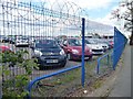
1
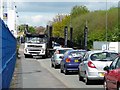
Car transporter, Mackadown Lane
The new use for the land on the west side of the lane has brought its own traffic jams.
Image: © Christine Johnstone
Taken: 16 May 2012
0.02 miles
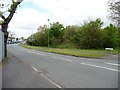
2
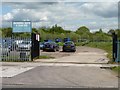
Sports field entrance, Mackadown Lane
The Mackadown Sports and Social Club itself is about 600 metres further up the lane.
Image: © Christine Johnstone
Taken: 16 May 2012
0.03 miles
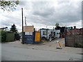
3
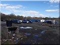
Waste ground off Mackadown Lane
The blue 'prefab' building in the background calls itself, rather grandly, The Mackadown Cafe; it appears to be associated with the adjacent playing fields just offshot to the right.
Image: © Richard Law
Taken: 16 Mar 2020
0.06 miles
4
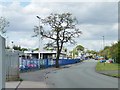
This tree has seen some changes
This end of Mackadown Lane used to be full of prefab houses. Now it is full of cars, parked for passengers from Birmingham Airport.
Image: © Christine Johnstone
Taken: 16 May 2012
0.07 miles
5
Airport parking, Mackadown Lane
Where once stood houses, now are parked cars.
Image: © Christine Johnstone
Taken: 16 May 2012
0.07 miles
6
Southern end of Mackadown Lane
Mackadown comes from the Anglo-Saxon "Macca's tun", meaning Macca's farm. This lane led north to that farm, which was the original centre of Sheldon.
Image: © Christine Johnstone
Taken: 16 May 2012
0.10 miles
7
Mackadown Spares, Mackadown Lane
Also the location of Court Autos Dismantlers.
Image: © Christine Johnstone
Taken: 16 May 2012
0.12 miles
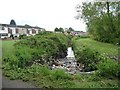
8

Carr around an anonymous brook
At the northeastern end of Radleys Park.
Image: © Christine Johnstone
Taken: 16 May 2012
0.12 miles
9
Rubbish in the brook, Radleys Park
Caught upstream of the culvert under the footpath.
Image: © Christine Johnstone
Taken: 16 May 2012
0.14 miles
10

The Radleys
Looking towards the junction with Mackadown Lane.
Image: © Christine Johnstone
Taken: 16 May 2012
0.15 miles