IMAGES TAKEN NEAR TO
Elmwoods, BIRMINGHAM, B32 3RF
Introduction
This page details the photographs taken nearby to Elmwoods, B32 3RF by members of the Geograph project.
The Geograph project started in 2005 with the aim of publishing, organising and preserving representative images for every square kilometre of Great Britain, Ireland and the Isle of Man.

There are currently over 7.5m images from over14,400 individuals and you can help contribute to the project by visiting https://www.geograph.org.uk
Image Map
Images are licensed for reuse under creativecommons.org/licenses/by-sa/2.0
Notes
- Clicking on the map will re-center to the selected point.
- The higher the marker number, the further away the image location is from the centre of the postcode.
Image Listing (6 Images Found)
Images are licensed for reuse under creativecommons.org/licenses/by-sa/2.0
Image
Details
Distance
1
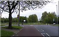
Woodgate Lane Junction
The junction with Wood Lane viewed from Adams Hill.
Image: © Gordon Griffiths
Taken: 9 May 2010
0.13 miles
2
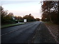
Clapgate Lane, Woodgate
A fairly early morning photo taken beside the Woodgate Business Park.
Image: © Richard Law
Taken: 2 Dec 2019
0.16 miles
3
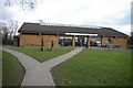
Visitor Centre, Woodgate Valley Country Park
Woodgate Valley Country Park is an area of countryside in the heart of Bartley Green and Quinton. The park comprises 450 acres of meadows, hedgerows and woodland with the Bourn Brook running through its centre. Originally a mosaic of farms and smallholdings the park has retained much of its rural character. The visitor centre is located off Clapgate Lane, and is the base for the rangers, as well as housing a cafe.
Image: © Phil Champion
Taken: 27 Jan 2007
0.22 miles
4
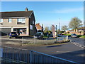
Small businesses and houses along Adams Hill in Bartley Green
Image: © Richard Law
Taken: 2 Dec 2019
0.24 miles
5
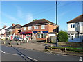
Local shop and bookies in Woodgate
The small shop also incorporates the Woodgate Post Office operation.
Image: © Richard Law
Taken: 2 Dec 2019
0.25 miles
6
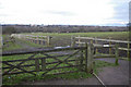
Footpath through Woodgate Valley Country Park
This footpath runs from near the Visitor Centre towards the Bourn Brook. The enclosed fields to either side are grazed by horses from the Hole Farm Trekking Centre
Image: © Phil Champion
Taken: 27 Jan 2007
0.25 miles