IMAGES TAKEN NEAR TO
Lye Close Lane, BIRMINGHAM, B32 3QS
Introduction
This page details the photographs taken nearby to Lye Close Lane, B32 3QS by members of the Geograph project.
The Geograph project started in 2005 with the aim of publishing, organising and preserving representative images for every square kilometre of Great Britain, Ireland and the Isle of Man.

There are currently over 7.5m images from over14,400 individuals and you can help contribute to the project by visiting https://www.geograph.org.uk
Image Map
Images are licensed for reuse under creativecommons.org/licenses/by-sa/2.0
Notes
- Clicking on the map will re-center to the selected point.
- The higher the marker number, the further away the image location is from the centre of the postcode.
Image Listing (31 Images Found)
Images are licensed for reuse under creativecommons.org/licenses/by-sa/2.0
Image
Details
Distance
3
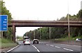
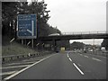
Bridge over the Southbound M5
Bridge taking Lye Close Lane over the southbound M5 motorway.
Image: © David Dixon
Taken: 1 Apr 2013
0.11 miles
5
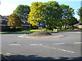
Island next to the south west end of Woodgate Valley
Image: © Stephen Rogerson
Taken: 2 Oct 2015
0.12 miles
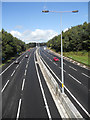
6

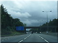
M5 North View
The view from Lye Close Lane bridge.
Image: © Gordon Griffiths
Taken: 24 May 2007
0.13 miles
9
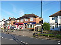
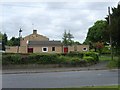
Local shop and bookies in Woodgate
The small shop also incorporates the Woodgate Post Office operation.
Image: © Richard Law
Taken: 2 Dec 2019
0.14 miles
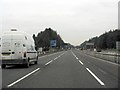
10
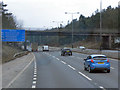
M5 Motorway - Junction 3 Exit Sign, Northbound
Image: © Whatlep
Taken: 19 Jan 2010
0.14 miles