IMAGES TAKEN NEAR TO
Kingsbridge Road, BIRMINGHAM, B32 3EU
Introduction
This page details the photographs taken nearby to Kingsbridge Road, B32 3EU by members of the Geograph project.
The Geograph project started in 2005 with the aim of publishing, organising and preserving representative images for every square kilometre of Great Britain, Ireland and the Isle of Man.

There are currently over 7.5m images from over14,400 individuals and you can help contribute to the project by visiting https://www.geograph.org.uk
Image Map
Images are licensed for reuse under creativecommons.org/licenses/by-sa/2.0
Notes
- Clicking on the map will re-center to the selected point.
- The higher the marker number, the further away the image location is from the centre of the postcode.
Image Listing (6 Images Found)
Images are licensed for reuse under creativecommons.org/licenses/by-sa/2.0
Image
Details
Distance
1
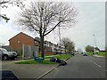
Bartley Green Boundary Sign on Jiggins Lane
Image: © Roy Hughes
Taken: 10 Apr 2014
0.04 miles
4
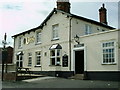
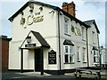
The Cock Inn
This public house is on Jiggins Lane.
Image: © Carl Baker
Taken: 4 Sep 2006
0.15 miles
6
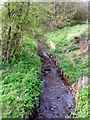
Bartley Brook, Bartley Green
Bartley Brook joins Stonehouse Brook which, in turn, joins Bourn Brook before finally joining the River Rea.
Image: © Roy Hughes
Taken: 10 Apr 2014
0.24 miles