IMAGES TAKEN NEAR TO
Quinton Lane, BIRMINGHAM, B32 2UD
Introduction
This page details the photographs taken nearby to Quinton Lane, B32 2UD by members of the Geograph project.
The Geograph project started in 2005 with the aim of publishing, organising and preserving representative images for every square kilometre of Great Britain, Ireland and the Isle of Man.

There are currently over 7.5m images from over14,400 individuals and you can help contribute to the project by visiting https://www.geograph.org.uk
Image Map
Images are licensed for reuse under creativecommons.org/licenses/by-sa/2.0
Notes
- Clicking on the map will re-center to the selected point.
- The higher the marker number, the further away the image location is from the centre of the postcode.
Image Listing (24 Images Found)
Images are licensed for reuse under creativecommons.org/licenses/by-sa/2.0
Image
Details
Distance
6
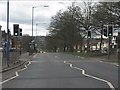
The traffic never stops.
This is one of the busiest routes out of Birmingham. The road connects with the M5 at junction 3 just over the hill in the distance.
Image: © Row17
Taken: 15 Apr 2010
0.12 miles
7
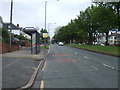
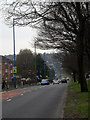
Bus stop and shelter on Hagley Road West
The A456 dual carriageway.
Image: © JThomas
Taken: 8 Jun 2019
0.12 miles
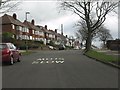
8
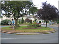
World's End Lane Roundabout
The well maintained floral displays on the roundabout at the junction of World's End Lane and Quinton Lane.
Image: © David Stowell
Taken: 2 Jul 2006
0.12 miles