IMAGES TAKEN NEAR TO
First Meadow Piece, BIRMINGHAM, B32 2QJ
Introduction
This page details the photographs taken nearby to First Meadow Piece, B32 2QJ by members of the Geograph project.
The Geograph project started in 2005 with the aim of publishing, organising and preserving representative images for every square kilometre of Great Britain, Ireland and the Isle of Man.

There are currently over 7.5m images from over14,400 individuals and you can help contribute to the project by visiting https://www.geograph.org.uk
Image Map
Images are licensed for reuse under creativecommons.org/licenses/by-sa/2.0
Notes
- Clicking on the map will re-center to the selected point.
- The higher the marker number, the further away the image location is from the centre of the postcode.
Image Listing (32 Images Found)
Images are licensed for reuse under creativecommons.org/licenses/by-sa/2.0
Image
Details
Distance
1
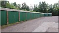
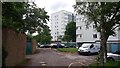
Garages on Welsh House Farm Estate
There are three large blocks of flats out of view on the right, part of the Welsh House Farm estate (unsurprisingly) built on the land of welsh House Farm. The line of the access road pictured preserves an old footpath alignment; the path ran from Home Farm, about 1km behind the photographer.
Image: © Paul Collins
Taken: 31 May 2017
0.09 miles
2
Flats and Garages on Welsh House Farm Estate
There are three large blocks of flats on the left, part of the Welsh House Farm estate (unsurprisingly) built on the land of welsh House Farm. The line of the access road pictured preserves an old footpath alignment; the path ran to Home Farm.
Image: © Paul Collins
Taken: 31 May 2017
0.10 miles
3
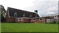
St Boniface Church
Viewed from the southeast, St Boniface is a Church of England parish church.
Image: © Paul Collins
Taken: 31 May 2017
0.10 miles
4
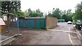
Flats and Garages on Welsh House Farm Estate
There are three large blocks of flats on the right, part of the Welsh House Farm estate (unsurprisingly) built on the land of welsh House Farm. The line of the access road pictured preserves an old footpath alignment; the path ran from Home Farm, about 1km behind the photographer.
Image: © Paul Collins
Taken: 31 May 2017
0.11 miles
6
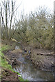
The Bourn Brook, Woodgate Valley Country Park
Looking upstream
Image: © Phil Champion
Taken: 27 Jan 2007
0.11 miles
7
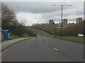
West Boulevard traverses the Woodgate Valley
Image: © Peter Whatley
Taken: 10 Mar 2012
0.11 miles
8
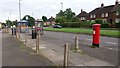
Street Furniture on Quinton Road West
The pillar box, bus stop and telephone kiosk all serve to connect a parade of shops and nearby houses.
Image: © Paul Collins
Taken: 31 May 2017
0.12 miles
9
Flats and Garages on Welsh House Farm Estate
There are three large blocks of flats on the right, part of the Welsh House Farm estate (unsurprisingly) built on the land of welsh House Farm. The line of the access road pictured preserves an old footpath alignment; the path ran from Home Farm, about 1km behind the photographer.
Image: © Paul Collins
Taken: 31 May 2017
0.12 miles
10

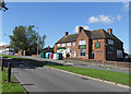
Shopping Parade on Quinton Road West
Photo taken at 17.30, so most of these businesses were closed.
Image: © Paul Collins
Taken: 31 May 2017
0.12 miles