IMAGES TAKEN NEAR TO
Welsh House Farm Road, BIRMINGHAM, B32 2JG
Introduction
This page details the photographs taken nearby to Welsh House Farm Road, B32 2JG by members of the Geograph project.
The Geograph project started in 2005 with the aim of publishing, organising and preserving representative images for every square kilometre of Great Britain, Ireland and the Isle of Man.

There are currently over 7.5m images from over14,400 individuals and you can help contribute to the project by visiting https://www.geograph.org.uk
Image Map
Images are licensed for reuse under creativecommons.org/licenses/by-sa/2.0
Notes
- Clicking on the map will re-center to the selected point.
- The higher the marker number, the further away the image location is from the centre of the postcode.
Image Listing (12 Images Found)
Images are licensed for reuse under creativecommons.org/licenses/by-sa/2.0
Image
Details
Distance
1
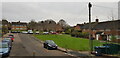
Capern Grove, Welsh House Farm Estate
The estate is named after the farm that formerly occupied the land.
Image: © Paul Collins
Taken: 28 Jan 2022
0.13 miles
2
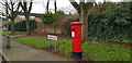
Pillar Box, Wisley Way, Welsh House Farm Estate
The estate is named after the farm that formerly occupied the land.
Image: © Paul Collins
Taken: 28 Jan 2022
0.17 miles
3
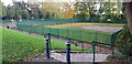
Bowling Green and Tennis Court, Queen's Park
Queen's Park was opened on 5th October 1898 to commemorate the 60th year of Queen Victoria's reign. The park remains popular with local residents, but the bowling green looks to be disused.
Image: © Paul Collins
Taken: 26 Oct 2022
0.17 miles
4
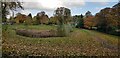
Queen's Park Flood Basin
This flood basin was created around 2018 as a flood prevention project. It holds run-off during heavy rain and provides a wetland habitat.
Image: © Paul Collins
Taken: 26 Oct 2022
0.17 miles
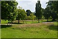
6
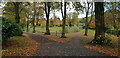
Queen's Park
Queen's Park was opened on 5th October 1898 to commemorate the 60th year of Queen Victoria's reign. The park remains popular with local residents. The Queen's Park Flood Basin can be seen through the trees.
Image: © Paul Collins
Taken: 26 Oct 2022
0.18 miles
7
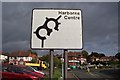
The Scarlett Pimpernel Pub, War Lane, Harborne.
Image: © Roy Hughes
Taken: 8 Jun 2011
0.19 miles
8
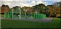
Games Court, Queen's Park
Queen's Park was opened on 5th October 1898 to commemorate the 60th year of Queen Victoria's reign. The park remains popular with local residents.
Image: © Paul Collins
Taken: 26 Oct 2022
0.19 miles
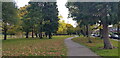
9
Queen's Park
Leafy corner of the city off Court Oak Road.
Image: © John M
Taken: 22 Jun 2014
0.22 miles
10
Queen's Park
Queen's Park was opened on 5th October 1898 to commemorate the 60th year of Queen Victoria's reign. The park remains popular with local residents.
Image: © Paul Collins
Taken: 26 Oct 2022
0.22 miles