IMAGES TAKEN NEAR TO
Worlds End Lane, BIRMINGHAM, B32 1JT
Introduction
This page details the photographs taken nearby to Worlds End Lane, B32 1JT by members of the Geograph project.
The Geograph project started in 2005 with the aim of publishing, organising and preserving representative images for every square kilometre of Great Britain, Ireland and the Isle of Man.

There are currently over 7.5m images from over14,400 individuals and you can help contribute to the project by visiting https://www.geograph.org.uk
Image Map
Images are licensed for reuse under creativecommons.org/licenses/by-sa/2.0
Notes
- Clicking on the map will re-center to the selected point.
- The higher the marker number, the further away the image location is from the centre of the postcode.
Image Listing (20 Images Found)
Images are licensed for reuse under creativecommons.org/licenses/by-sa/2.0
Image
Details
Distance
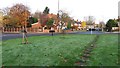
1
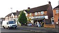
Fruiterer In Worlds End Lane
A nice old-fashioned fruiterer. Personally, I've always wondered why these shops are often called 'fruiterers' and not 'fruiters' in the way of, say, confectioners, butchers or grocers.
Image: © Paul Collins
Taken: 17 Nov 2017
0.09 miles
2

Quinton Evangelical Church
This church is on the corner of Worlds End Lane and Ridgacre Road. In 2016 or 2017 the fence shown replaced a hedge along the road frontage.
Image: © Paul Collins
Taken: 17 Nov 2017
0.10 miles
3
Quinton Evangelical Church
This one doesn't really need a title, the name is clear to see. The church lies on World's End Lane (rather ironically, I thought) at the junction with Ridgeacre Road.
Image: © Richard Law
Taken: 2 Oct 2019
0.10 miles
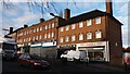
4
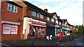
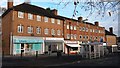
Worlds End Lane Post Office and Shopping Parade
Image: © Paul Collins
Taken: 17 Nov 2017
0.11 miles
5
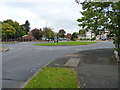
Roundabout on Ridgacre Road
At the junction with Worlds End Lane.
Image: © Richard Law
Taken: 2 Oct 2019
0.12 miles
6
Young Trees on Roundabout in Ridgacre Road
This roundabout sports several carefully planted young trees including a tiny fir visible in the centre of this image.
Image: © Paul Collins
Taken: 17 Nov 2017
0.13 miles
7
Shopping Parade on Faraday Avenue
This parade forms part of a local shopping centre at the junction with Worlds End Lane.
Image: © Paul Collins
Taken: 17 Nov 2017
0.13 miles
8
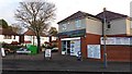
Worlds End Lane Superstore
This shop and several others adjacent cater for local shopping needs.
Image: © Paul Collins
Taken: 17 Nov 2017
0.14 miles
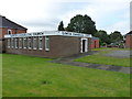
9
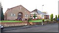
Our Lady of Fatima Catholic Church, Quinton
This church was opened and consecrated on 7th October 1978 (Feast of the Holy Rosary). The parish hall is the building pictured left; whereas the church itself is to the right.
Image: © Paul Collins
Taken: 17 Nov 2017
0.14 miles
10
Shopping Parade on Faraday Avenue
This parade forms part of a local shopping centre at the junction with Worlds End Lane.
Image: © Paul Collins
Taken: 17 Nov 2017
0.14 miles