IMAGES TAKEN NEAR TO
Cox Street, BIRMINGHAM, B3 1RD
Introduction
This page details the photographs taken nearby to Cox Street, B3 1RD by members of the Geograph project.
The Geograph project started in 2005 with the aim of publishing, organising and preserving representative images for every square kilometre of Great Britain, Ireland and the Isle of Man.

There are currently over 7.5m images from over14,400 individuals and you can help contribute to the project by visiting https://www.geograph.org.uk
Image Map
Images are licensed for reuse under creativecommons.org/licenses/by-sa/2.0
Notes
- Clicking on the map will re-center to the selected point.
- The higher the marker number, the further away the image location is from the centre of the postcode.
Image Listing (556 Images Found)
Images are licensed for reuse under creativecommons.org/licenses/by-sa/2.0
Image
Details
Distance
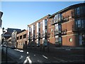
2
Beyond locked gates
Locked steel gates on Livery Street secure the railway west of the Snow Hill Viaduct, offering a glimpse of decaying industrial buildings beyond, by Constitution Hill.
Image: © A J Paxton
Taken: 23 Mar 2022
0.04 miles
3
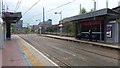
St Paul's Metro stop
A view of the Metro station looking towards the city centre.
Image: © Peter Mackenzie
Taken: 12 May 2017
0.04 miles
4
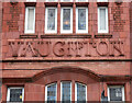
Detail of 45 Livery Street, Birmingham
Fine lettering in terracotta reading "Vaughton" (flanked by "Gothic" and "Works" out of shot).
Image: © Stephen Richards
Taken: 23 Jun 2015
0.04 miles
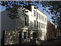
5
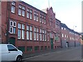
Jewellery Quarter - Vaughton 'Gothic Works' - Livery Street
Grade II listed building dating from 1902. The missing terracotta can be made out as Goldsmiths and Silversmiths. The firm specialised in mayoral chains and civic jewellery.Now converted as a budget hostel.
Image: © John M
Taken: 21 Oct 2010
0.04 miles
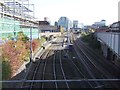
6
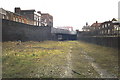
Snow Hill approach - Livery Street
Trackbed approach to junction of Livery Street and Howard Street north of Snow Hill Station.
The buildings on left are now expensive penthouses / flats.
The right-hand side of the trackbed is now the location of a station on Metro line between Wolverhampton and Snow Hill serving St Pauls Square area, whilst the cross-city line between Stourbridge and Leamington Spa uses the left-hand side.
Image: © Michael Westley
Taken: Unknown
0.05 miles
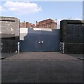
7
Snow Hill approach - Constitution Hill
Rear of factories behind Constitution Hill, at site of the now metro station for St Pauls Square. Notice the elevated section on left, probably once used for shunting and storing engines alongside the busy Snow Hill - Wolverhampton route.
Image: © Michael Westley
Taken: Unknown
0.05 miles
8
St Paul's tram stop
The bulk of Snow Hill is seen beyond.
Image: © Chris Allen
Taken: 20 Dec 2014
0.05 miles
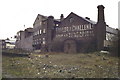
9
St Paul's House - Jewellery Quarter
Originally a four storey jewellery factory constructed for the Goode family in 1853. Up to 400 persons were employed in the manufacture of gold chains.
Image: © John M
Taken: 30 Oct 2012
0.05 miles
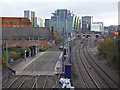
10
St Paul's Metro Station
It is a single stop from the office blocks towering over Snow Hill Station.
Image: © John M
Taken: 30 Oct 2012
0.05 miles