IMAGES TAKEN NEAR TO
Fleet Street, BIRMINGHAM, B3 1JL
Introduction
This page details the photographs taken nearby to Fleet Street, B3 1JL by members of the Geograph project.
The Geograph project started in 2005 with the aim of publishing, organising and preserving representative images for every square kilometre of Great Britain, Ireland and the Isle of Man.

There are currently over 7.5m images from over14,400 individuals and you can help contribute to the project by visiting https://www.geograph.org.uk
Image Map
Images are licensed for reuse under creativecommons.org/licenses/by-sa/2.0
Notes
- Clicking on the map will re-center to the selected point.
- The higher the marker number, the further away the image location is from the centre of the postcode.
Image Listing (1419 Images Found)
Images are licensed for reuse under creativecommons.org/licenses/by-sa/2.0
Image
Details
Distance
1
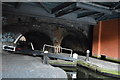
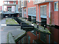
Canalside, Islington Gates
Islington Gates is a new development of flats / apartments between Fleet Street and the Birmingham and Fazeley Canal. They have been built over the side pounds of the Farmers Bridge flight of locks. When locks are close together, like these, side pounds [or wider sections of water] are needed to work the locks efficiently.
Image: © Christine Johnstone
Taken: 16 May 2012
0.00 miles
2
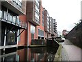
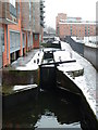
Farmer's Bridge locks
A flight of locks on the Birmingham and Fazeley canal, overlooked by new apartments in what was once a heavily industrialised area. To the right is the site of the former Birmingham Museum of Science and Industry, now demolished for redevelopment.
From E Gammie Image]
The exhibits are split between the Thinktank museum, Millennium point or the storage facility.
Image: © Ashley Dace
Taken: 19 Feb 2011
0.00 miles
3
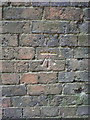
OS benchmark, canalside, rear of Newhall Street
An OS cutmark on the wall of a former factory/works building, which faces onto the towpath of the canal. Originally levelled, probably in 1956, at 123.862m above Ordnance Datum Newlyn.
Image: © Richard Law
Taken: 21 Mar 2016
0.01 miles
4
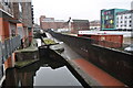
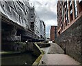
Farmer's Bridge Locks No 8, Birmingham
The regeneration of the area by the canal here has office and apartment buildings which are constructed partly over the former wide side ponds. This makes it appear as if the basements of the buildings are flooded, or in some cases had been used as boat loading areas. Information from the BCN society is worth viewing here http://www.bcn-society.co.uk/BCNS_Photo_Gallery9.php#Photographs%20From%20the%20Recent%20Past .
Image: © Roger D Kidd
Taken: 27 Sep 2008
0.01 miles

6
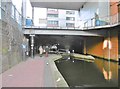
Birmingham, Lock No 9
Under Newhall Street, on Bakers Hill Locks, Birmingham to Fazeley Canal.
Image: © Mike Faherty
Taken: 3 Feb 2019
0.01 miles
7
Farmer's Bridge Locks
From Newhall Street. The former Birmingham Museum of Science and Industry used to be on the right.
Image: © Chris Allen
Taken: 28 Dec 2010
0.01 miles
8
Construction work along the Birmingham and Fazeley Canal
At Farmer's Bridge Lock No 8, which is part of the Farmer's Bridge Lock Flight, which comprises 13 locks and a rise of 81 feet.
Image: © Mat Fascione
Taken: 31 Jul 2022
0.01 miles
9
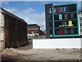
The old and the new
A development off Newhall Street, with an old building which looks forlorn a short distance from the brightly coloured offices. Will the new building last as long as the other?
Image: © David Smith
Taken: 30 Apr 2010
0.01 miles