IMAGES TAKEN NEAR TO
Dimsdale Road, BIRMINGHAM, B31 5RD
Introduction
This page details the photographs taken nearby to Dimsdale Road, B31 5RD by members of the Geograph project.
The Geograph project started in 2005 with the aim of publishing, organising and preserving representative images for every square kilometre of Great Britain, Ireland and the Isle of Man.

There are currently over 7.5m images from over14,400 individuals and you can help contribute to the project by visiting https://www.geograph.org.uk
Image Map
Images are licensed for reuse under creativecommons.org/licenses/by-sa/2.0
Notes
- Clicking on the map will re-center to the selected point.
- The higher the marker number, the further away the image location is from the centre of the postcode.
Image Listing (19 Images Found)
Images are licensed for reuse under creativecommons.org/licenses/by-sa/2.0
Image
Details
Distance
1

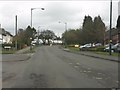
Houses on Trescott Road
This estate has the look of 1950s corporation housing about it.
Image: © Richard Law
Taken: 20 Jan 2020
0.10 miles
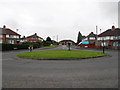
3

Norrington Road, Frankley
Norrington Road runs around part of this elliptical shaped housing estate on the edge of the Birmingham conurbation.
Image: © David Stowell
Taken: 26 May 2006
0.14 miles
4
Site of St Bartholomews Church, Hoggs Lane, Northfield
A church used to stand on the site now occupied by the trees. It is,however, still shown on the OS map! The photograph is taken from Bidford Road looking towards Allens Farm Road with Hoggs Lane crossing left to right. The small black building on the left hand side was used as a Scout hut.The original building (erected in 1938) was demolished in 2006 following an arson attack in 1998. The local congregation presently worship every Sunday in Hollymoor Old Chapel, Manor Park Grove
Image: © Roy Hughes
Taken: 1 Jan 2009
0.15 miles
5

Houses off Frankley Beeches Road
Semi-detached urban housing (possibly Urban District Council) from a period around the 1950s.
Image: © Richard Law
Taken: 20 Jan 2020
0.15 miles

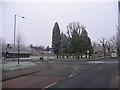
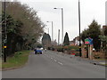
9

Southern end of Hoggs Lane
Mini-roundabouts have been constructed at several of the junctions on Hoggs Lane.
Image: © Peter Whatley
Taken: 10 Mar 2012
0.17 miles
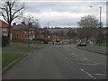
10
Frankley Beeches Road at Hanging Lane junction
On the left is the North Worcestershire Golf Club which is soon to disappear.
Image: © Jeff Gogarty
Taken: 21 Mar 2016
0.18 miles