IMAGES TAKEN NEAR TO
Fitzroy Road, BIRMINGHAM, B31 5PG
Introduction
This page details the photographs taken nearby to Fitzroy Road, B31 5PG by members of the Geograph project.
The Geograph project started in 2005 with the aim of publishing, organising and preserving representative images for every square kilometre of Great Britain, Ireland and the Isle of Man.

There are currently over 7.5m images from over14,400 individuals and you can help contribute to the project by visiting https://www.geograph.org.uk
Image Map
Images are licensed for reuse under creativecommons.org/licenses/by-sa/2.0
Notes
- Clicking on the map will re-center to the selected point.
- The higher the marker number, the further away the image location is from the centre of the postcode.
Image Listing (17 Images Found)
Images are licensed for reuse under creativecommons.org/licenses/by-sa/2.0
Image
Details
Distance
1
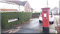
Pillar Box in Borrowdale Road
This pillar box is found at the junction of Borrowdale Road and Norrington Road within an inter-war housing estate.
Image: © Paul Collins
Taken: 10 Nov 2016
0.12 miles
2

School, Norrington Road
The school buildings near the entrance to this housing estate off Frankley Beeches Road.
Image: © David Stowell
Taken: 26 May 2006
0.14 miles
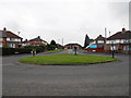
4

Norrington Road, Frankley
Norrington Road runs around part of this elliptical shaped housing estate on the edge of the Birmingham conurbation.
Image: © David Stowell
Taken: 26 May 2006
0.15 miles
5
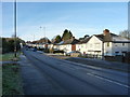
Looking west-southwest along Frankley Beeches Road
Image: © Richard Law
Taken: 20 Jan 2020
0.16 miles
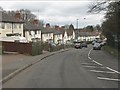
7

Houses off Frankley Beeches Road
Semi-detached urban housing (possibly Urban District Council) from a period around the 1950s.
Image: © Richard Law
Taken: 20 Jan 2020
0.18 miles
8
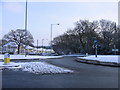
Egghill Lane, Frankley Beeches Island
The island at the road junction opposite the Dingle Pub.
Image: © Roy Hughes
Taken: 3 Feb 2009
0.18 miles
9

Frankley Beeches Road.
At the junction with Norrington Road.
Image: © David Stowell
Taken: 26 May 2006
0.18 miles
10
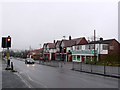
Egghill Lane
This part of Egghill Lane with the traffic lights and pedestrian crossing is in the very south of the square. The row of shops is in SP0078.
Image: © Nigel Mykura
Taken: 19 Feb 2011
0.20 miles