IMAGES TAKEN NEAR TO
Alvechurch Road, BIRMINGHAM, B31 4UB
Introduction
This page details the photographs taken nearby to Alvechurch Road, B31 4UB by members of the Geograph project.
The Geograph project started in 2005 with the aim of publishing, organising and preserving representative images for every square kilometre of Great Britain, Ireland and the Isle of Man.

There are currently over 7.5m images from over14,400 individuals and you can help contribute to the project by visiting https://www.geograph.org.uk
Image Map
Images are licensed for reuse under creativecommons.org/licenses/by-sa/2.0
Notes
- Clicking on the map will re-center to the selected point.
- The higher the marker number, the further away the image location is from the centre of the postcode.
Image Listing (15 Images Found)
Images are licensed for reuse under creativecommons.org/licenses/by-sa/2.0
Image
Details
Distance
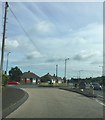
2
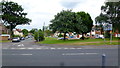
A441 Junction With Longbridge Lane B4096
Image: © Roy Hughes
Taken: 31 May 2016
0.03 miles
3
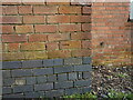
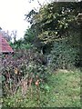
OS benchmark - Dingle House Farm
An OS cutmark on an outbuilding at Dingle House Farm; originally levelled in 1966 at 189.037m above Ordnance Datum Newlyn
Image: © Richard Law
Taken: 26 Feb 2020
0.04 miles
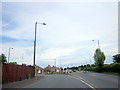
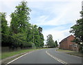
5
Alvechurch Road, West Heath
The B4096 Longbridge Road which crosses the scene marks the southern edge of the Greater Birmingham conurbation.
Image: © Jonathan Billinger
Taken: 30 Jul 2013
0.05 miles
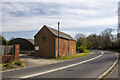
7
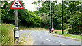
Dog-walking, Longbridge Lane
Edge-of-suburbia activities.
Image: © Jonathan Billinger
Taken: 30 Jul 2013
0.07 miles
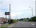
10
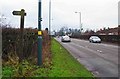
Redditch Road (A441), West Heath
The A441 is seen here on the approach to its junction with Longbridge Lane (B4096). A short section of the North Worcestershire Way runs along this part of the A441 and turns off into fields by the marker post on the left. This is inscribed with the name of the path.
Image: © P L Chadwick
Taken: 17 Dec 2016
0.13 miles