IMAGES TAKEN NEAR TO
Wootton Road, BIRMINGHAM, B31 4ST
Introduction
This page details the photographs taken nearby to Wootton Road, B31 4ST by members of the Geograph project.
The Geograph project started in 2005 with the aim of publishing, organising and preserving representative images for every square kilometre of Great Britain, Ireland and the Isle of Man.

There are currently over 7.5m images from over14,400 individuals and you can help contribute to the project by visiting https://www.geograph.org.uk
Image Map
Images are licensed for reuse under creativecommons.org/licenses/by-sa/2.0
Notes
- Clicking on the map will re-center to the selected point.
- The higher the marker number, the further away the image location is from the centre of the postcode.
Image Listing (16 Images Found)
Images are licensed for reuse under creativecommons.org/licenses/by-sa/2.0
Image
Details
Distance
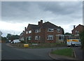
2
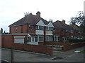
Wootton Road
Looking south - junction with Longmeadow Grove.
Image: © JThomas
Taken: 22 Jul 2017
0.02 miles
4
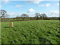
View to the east from Cofton Common trig
Open fields and hedges, with a little-used footpath somewhere over to the right. It was barely noticeable on the ground in early 2020.
Image: © Richard Law
Taken: 26 Feb 2020
0.14 miles
5
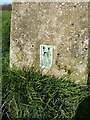
OS Flush Bracket S4020 on Cofton Common trig
The Flush Bracket (or more accurately the bolt inside/beneath the trig) marks a spot height of 201.338m above Ordnance Datum Newlyn, as levelled in 1966.
Image: © Richard Law
Taken: 26 Feb 2020
0.15 miles
6
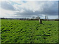
Cofton Common trig point
The trig stands in a field, not noticeably on a prominent hill. The moat that's marked on the maps is barely visible on the ground, but may be more evident as a buried feature.
Image: © Richard Law
Taken: 26 Feb 2020
0.15 miles
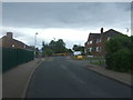
9
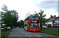
Groveley Lane (B4096)
Looking north east.
West Midlands bus, Reg. No. BV52 OAP on the 49E route.
Image: © JThomas
Taken: 22 Jul 2017
0.17 miles
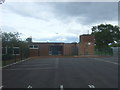
10
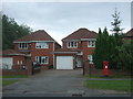
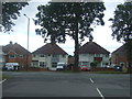
Houses on Groveley Lane
Showing position of Postbox No. B31 967.
See Image] for postbox.
Image: © JThomas
Taken: 22 Jul 2017
0.18 miles