IMAGES TAKEN NEAR TO
Falfield Grove, BIRMINGHAM, B31 4LT
Introduction
This page details the photographs taken nearby to Falfield Grove, B31 4LT by members of the Geograph project.
The Geograph project started in 2005 with the aim of publishing, organising and preserving representative images for every square kilometre of Great Britain, Ireland and the Isle of Man.

There are currently over 7.5m images from over14,400 individuals and you can help contribute to the project by visiting https://www.geograph.org.uk
Image Map
Images are licensed for reuse under creativecommons.org/licenses/by-sa/2.0
Notes
- Clicking on the map will re-center to the selected point.
- The higher the marker number, the further away the image location is from the centre of the postcode.
Image Listing (92 Images Found)
Images are licensed for reuse under creativecommons.org/licenses/by-sa/2.0
Image
Details
Distance
1
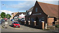
Christadelphian Hall, Longbridge Lane
Proudly standing opposite railway station, and close to Sunbury Road. Longbridge
Image: © Michael Westley
Taken: 9 May 2011
0.06 miles
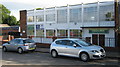
2
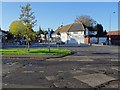
Shops on Sunbury Road
Shops on the corner of Longbridge Lane and Sunbury Road early on a Sunday morning.
Image: © Philip Halling
Taken: 28 Oct 2018
0.06 miles
3
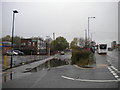
Old course of Longbridge Lane, Longbridge
Now a cul de sac leading to a footbridge across the railway; the current Longbridge Lane is slightly higher up on the right, hence the large puddle collecting in the foreground.
Image: © Richard Vince
Taken: 2 Nov 2019
0.06 miles
4
That's It - no more plans for trains to Frankley
The trackbed of former line to Frankley and Halesowen has now been filled in, and the cross-over tracks disconnected. The site behind was once the Leyland Car Plant.
A short while before Image
Image]
Image]
Image: © Michael Westley
Taken: 12 Feb 2012
0.06 miles
5
Greenlands Social Club, Longbridge
Opposite railway station and pedestrian crossing, in (now) cul-de-sac
Image: © Michael Westley
Taken: 9 May 2011
0.06 miles
6
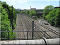
Former Junction For Halesowen - Five Years On
An up-date of an image taken five years ago. Most of the factory and the railway lines to the Longbridge Works/Halesowen Branch have disappeared Image
Image: © Roy Hughes
Taken: 3 Jun 2011
0.07 miles
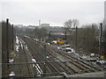
7

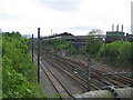
Longbridge Junction
The two lines diverging to the right are the former access to the ex-Rover car factory (or British Leyland if you have a longer memory). In earlier times they formed a branch line to Halesowen. An electric unit is entering the reversing siding south of Longbridge station, prior to forming a working to Four Oaks.
Image: © Peter Whatley
Taken: 22 Sep 2008
0.07 miles
8
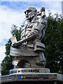
Close look at sculpture at the Longbridge Interchange
This is located close to a bus shelter, and a short walk from the railway station.
Image: © Ruth Sharville
Taken: 5 Aug 2022
0.07 miles
9
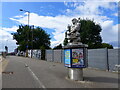
Sculpture at Longbridge near bus shelter
See Image for a close look.
Image: © Ruth Sharville
Taken: 5 Aug 2022
0.07 miles
10
Former junction for Halesowen
Looking from the Longbridge Lane overbridge along the Birmingham - Bristol main line. The pair of tracks to the right latterly served the Longbridge car plant but originally continued as the branch line to Halesowen and the junction with the Snowhill - Stourbridge line at SO962858.
For the same scene five years later see Image
Image: © David Stowell
Taken: 26 May 2006
0.07 miles