IMAGES TAKEN NEAR TO
Longbridge Lane, BIRMINGHAM, B31 4LA
Introduction
This page details the photographs taken nearby to Longbridge Lane, B31 4LA by members of the Geograph project.
The Geograph project started in 2005 with the aim of publishing, organising and preserving representative images for every square kilometre of Great Britain, Ireland and the Isle of Man.

There are currently over 7.5m images from over14,400 individuals and you can help contribute to the project by visiting https://www.geograph.org.uk
Image Map
Images are licensed for reuse under creativecommons.org/licenses/by-sa/2.0
Notes
- Clicking on the map will re-center to the selected point.
- The higher the marker number, the further away the image location is from the centre of the postcode.
Image Listing (56 Images Found)
Images are licensed for reuse under creativecommons.org/licenses/by-sa/2.0
Image
Details
Distance
1
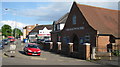
Shops on Sunbury Road
Shops on the corner of Longbridge Lane and Sunbury Road early on a Sunday morning.
Image: © Philip Halling
Taken: 28 Oct 2018
0.09 miles
2
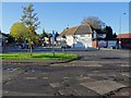
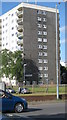
South end of Central Avenue, Longbridge
Seen from Longbridge Lane, with Coney Green House dominating the scene.
Image: © Richard Vince
Taken: 2 Nov 2019
0.10 miles
3
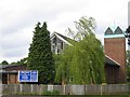
Parish Church of St John the Baptist, Longbridge
In Longbridge Lane at the junction with Turves Green.
Image: © David Stowell
Taken: 26 May 2006
0.11 miles
4
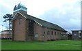
St. John the Baptist's church, Longbridge
Built in 1957 to serve the then-burgeoning car-making suburb, this interesting building appears to be orientated north-east - south-west.
Viewed from the north.
Image: © Jonathan Billinger
Taken: 4 Dec 2008
0.11 miles
5
Christadelphian Hall, Longbridge Lane
Proudly standing opposite railway station, and close to Sunbury Road. Longbridge
Image: © Michael Westley
Taken: 9 May 2011
0.11 miles
6
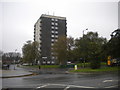
Coney Green House, Longbridge
Block of flats at intersection of Central Avenue and Longbridge Lane near to the station
Image: © Michael Westley
Taken: 9 May 2011
0.11 miles
7
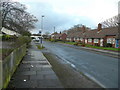
Culmington Road, Longbridge
A 1950's suburban road in the south-west of the Greater Birmingham metropolis.
Image: © Jonathan Billinger
Taken: 4 Dec 2008
0.11 miles
8
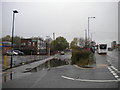
Old course of Longbridge Lane, Longbridge
Now a cul de sac leading to a footbridge across the railway; the current Longbridge Lane is slightly higher up on the right, hence the large puddle collecting in the foreground.
Image: © Richard Vince
Taken: 2 Nov 2019
0.13 miles
9
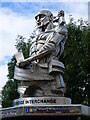
Close look at sculpture at the Longbridge Interchange
This is located close to a bus shelter, and a short walk from the railway station.
Image: © Ruth Sharville
Taken: 5 Aug 2022
0.13 miles
10
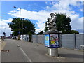
Sculpture at Longbridge near bus shelter
See Image for a close look.
Image: © Ruth Sharville
Taken: 5 Aug 2022
0.13 miles