IMAGES TAKEN NEAR TO
Willetts Road, BIRMINGHAM, B31 4BE

Introduction

This page details the photographs taken nearby to Willetts Road, B31 4BE by members of the Geograph project.

The Geograph project started in 2005 with the aim of publishing, organising and preserving representative images for every square kilometre of Great Britain, Ireland and the Isle of Man.

There are currently over 7.5m images from over14,400 individuals and you can help contribute to the project by visiting https://www.geograph.org.uk

Image Map


Images are licensed for reuse under creativecommons.org/licenses/by-sa/2.0
Notes
  • Clicking on the map will re-center to the selected point.
  • The higher the marker number, the further away the image location is from the centre of the postcode.

Image Listing (38 Images Found)

Images are licensed for reuse under creativecommons.org/licenses/by-sa/2.0
  • ...
Image
Details
Distance
1
OS benchmark - Turves Green, electricity substation building
An OS cutmark on the wall of what appears to be a substation house, last levelled in 1965 at 167.347m above Ordnance Datum Newlyn.
Image: © Richard Law Taken: 26 Feb 2020
0.07 miles
2
The Woodpecker, Turves Green, Birmingham
Image: © Jeff Gogarty Taken: 28 Sep 2016
0.14 miles
3
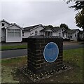
Austin Village Monument Part 1
The blue plaque on this side of the pedestal reads: "Birmingham Civic Society 2002 The Austin Village Built by Herbert Austin in 1917 to house his workforce for the Austin Motor Company, at that time engaged in the manufacture of vehicles, aircraft, ammunition and equipment to support this country's forces in the Great War." The pedestal stands on the central reservation of Central Avenue, a miniature dual carriageway in the heart of the village. Behind it can be seen four of the cedarwood bungalows imported by Austin from the USA. For the blue plaque on the other side of the pedestal see Image
Image: © A J Paxton Taken: 16 Sep 2023
0.15 miles
4
Austin Village monument Part 2
The blue plaque on this side of the pedestal reads: "This plaque was erected in 2002 by members of the Austin Village Preservation Society to commemorate the life of Herbert Austin 1866-1941 The unique cedar wood bungalows were transported from Bay City, U.S.A. Conservation status granted by Birmingham City Council in 1997. This project was funded by Phoenix Venture Holdings." For the blue plaque on the other side of the pedestal, see Image
Image: © A J Paxton Taken: 16 Sep 2023
0.15 miles
5
Hawkesley Drive, Austin Village Conservation Area
Northfield, Birmingham
Image: © Jeff Gogarty Taken: 28 Sep 2016
0.17 miles
6
Under the Eye of Mordor, Austin Village
These are three of the two hundred cedarwood houses of the 'Chester' type imported from the USA by Herbert Austin and erected in Longbridge, Birmingham in 1917 to house wartime workers at his factory. Six or seven women munitions workers would typically live in each three-bedroomed bungalow. They were well-appointed by British standards of the time, with an indoor toilet, and central heating powered by a coke-fired boiler. The houses have survived, in private ownership and in various stages of modernisation. The middle house of the three shown here is probably the best-preserved and is a grade A locally-listed building (see the Birmingham list https://www.birmingham.gov.uk/downloads/download/273/locally_listed_buildings ). It appears to have retained its original wooden clapboarding, used at Austin Village in place of the wooden shingles of the North American house. The American open porch was glazed over in the Austin Village version, supposedly because of the inclement British weather, but also perhaps because sitting on your porch or in your front garden is a very un-British thing to do. Wooden houses require regular maintenance, and over time they have been modernised by their owners, as the houses to either side illustrate, giving the area a varied appearance, very like that of suburbs in the USA and Canada, but disapproved of by conservationists. The village was declared a conservation area in 1997 but now risks losing this status, which would in turn increase the risk of developers buying up plots and replacing the historic bungalows with higher-density housing. One such developer is apparently known to local people as 'The Eye of Mordor'. On the Chester house see the Austin Village stories site https://www.theaustinvillage.com/new-page . On the conservation debate, see Image
Image: © A J Paxton Taken: 16 Sep 2023
0.17 miles
7
River Rea, Off Mill Lane, Northfield.
Image: © Roy Hughes Taken: 21 Mar 2009
0.18 miles
8
Turves Green Girls School, Northfield, Birmingham
Official name Turves Green Girls' School and Technology College, Birmingham. There is a primary school separating the girls and boys high schools.
Image: © Jeff Gogarty Taken: 28 Sep 2016
0.18 miles
9
Top of a steep climb
From The Mill Walk to Hawkesley Crescent there is a way to avois walking on the road but it is a steep climb. Turves Green, Northfield, Birmingham
Image: © Jeff Gogarty Taken: 8 Mar 2016
0.18 miles
10
River Rea
The River Rea flows from the Lickey Hills near Rubery through southern Birmingham before finally joining the Tame to the north east of the city centre. Here in Northfield, just after it passes under Coleys Lane it is little more than a large stream.
Image: © David Stowell Taken: 26 May 2006
0.19 miles
  • ...