IMAGES TAKEN NEAR TO
Harpers Road, BIRMINGHAM, B31 4AR
Introduction
This page details the photographs taken nearby to Harpers Road, B31 4AR by members of the Geograph project.
The Geograph project started in 2005 with the aim of publishing, organising and preserving representative images for every square kilometre of Great Britain, Ireland and the Isle of Man.

There are currently over 7.5m images from over14,400 individuals and you can help contribute to the project by visiting https://www.geograph.org.uk
Image Map
Images are licensed for reuse under creativecommons.org/licenses/by-sa/2.0
Notes
- Clicking on the map will re-center to the selected point.
- The higher the marker number, the further away the image location is from the centre of the postcode.
Image Listing (48 Images Found)
Images are licensed for reuse under creativecommons.org/licenses/by-sa/2.0
Image
Details
Distance
2

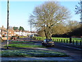
Small green by St Peter's Avenue, Northfield, Birmingham
Image: © Jeff Gogarty
Taken: 28 Sep 2015
0.10 miles
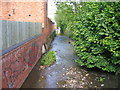
4
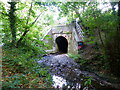
Bridge where the River Rea passes under the main line railway, Northfield
Image: © Ruth Sharville
Taken: 5 Aug 2022
0.14 miles
5
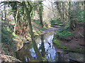
River Rea passes under a railway line
The end of a small attractive section of River Rea's journey through the suburbs of Birmingham.
Image: © Jeff Gogarty
Taken: 28 Sep 2015
0.14 miles
6
River Rea
The River Rea flows from the Lickey Hills near Rubery through southern Birmingham before finally joining the Tame to the north east of the city centre. Here in Northfield, just after it passes under Coleys Lane it is little more than a large stream.
Image: © David Stowell
Taken: 26 May 2006
0.15 miles
7
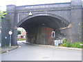
Bridge at Mill Lane and Station Road, Northfield
When the original bridge under the Birmingham and Bristol railway was built this would have been a rural area and so it only had sufficient width to carry a single line of traffic. By the time the line was widened to four tracks clearly there was seen to be a need to widen the road and so the newer part of the bridge, in blue brick, was constructed accordingly. The arch of older part of the bridge however has never been rebuilt hence this unusual looking structure with traffic controlled by lights.
Image: © David Stowell
Taken: 26 May 2006
0.15 miles
8
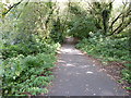
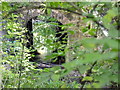
Cycle path through wooded area
Running parallel to Mill Lane, Northfield, Birmingham.
The River Rea also runs through these woods.
Image: © Jeff Gogarty
Taken: 28 Sep 2015
0.15 miles
9
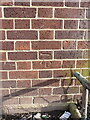
OS benchmark - Turves Green, electricity substation building
An OS cutmark on the wall of what appears to be a substation house, last levelled in 1965 at 167.347m above Ordnance Datum Newlyn.
Image: © Richard Law
Taken: 26 Feb 2020
0.16 miles
10
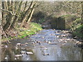
River Rea From The Ford, Mill Walk, Northfield.
Image: © Roy Hughes
Taken: 21 Mar 2009
0.16 miles