IMAGES TAKEN NEAR TO
Moor Leasow, BIRMINGHAM, B31 3XL
Introduction
This page details the photographs taken nearby to Moor Leasow, B31 3XL by members of the Geograph project.
The Geograph project started in 2005 with the aim of publishing, organising and preserving representative images for every square kilometre of Great Britain, Ireland and the Isle of Man.

There are currently over 7.5m images from over14,400 individuals and you can help contribute to the project by visiting https://www.geograph.org.uk
Image Map
Images are licensed for reuse under creativecommons.org/licenses/by-sa/2.0
Notes
- Clicking on the map will re-center to the selected point.
- The higher the marker number, the further away the image location is from the centre of the postcode.
Image Listing (19 Images Found)
Images are licensed for reuse under creativecommons.org/licenses/by-sa/2.0
Image
Details
Distance
1
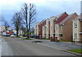
New housing, Staple Lodge Road
Old 1950's housing with large gardens has been cleared to create land for high density accommodation in this area to the west of King's Norton.
Image: © Jonathan Billinger
Taken: 4 Dec 2008
0.05 miles
2

National Cycle Network route 5 (Rea Valley Route)
Image: © Row17
Taken: 5 Jun 2009
0.08 miles
3
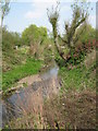
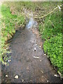
River Rea Looking Towards Wychall Road Bridge.
Taken from just off the River Rea walkway.
Image: © Roy Hughes
Taken: 20 Apr 2009
0.10 miles
4
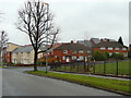
Variety of housing, Staple Lodge Road
The old semi's are being boarded-up as a precurser to using the site for new high-density units like those beyond?
Image: © Jonathan Billinger
Taken: 28 Jan 2009
0.11 miles
5
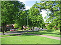
Staple Lodge Road
This is an area of modern housing looking at its best with the sun on the spring greenery.
Image: © David Stowell
Taken: 26 May 2006
0.13 miles
6

The Rea Valley Cycle Route No. 5 about to cross Wychall Road
Image: © Roy Hughes
Taken: 8 Oct 2021
0.15 miles
7

Oddingley Hall
The hall is a modern community centre. In 2017 the hall was advertised as being to let for community use under a 'community asset transfer'.
Image: © Paul Collins
Taken: 9 Jan 2018
0.15 miles
8

The Rea Valley Cycle Route No. 5 at Wychall Road
Image: © Roy Hughes
Taken: 8 Oct 2021
0.17 miles
9
River Rea From Wychall Road Bridge
Looking north towards city.
Image: © Roy Hughes
Taken: 20 Apr 2009
0.19 miles
10

Royal Cypher on Edward VIII postbox, Middlemore Road, Northfield, Birmingham
The postbox has been repainted so many times, although not recently, that the crown and Royal Cypher are no longer very sharp. There seems to be no definite figure for the number of surviving Edward VIII boxes in the country, but one source quotes about 130. But most of the figures quoted, which vary widely, seem to be based on pure guesswork.
Image
Image: © P L Chadwick
Taken: 21 Nov 2015
0.19 miles