IMAGES TAKEN NEAR TO
Burnlea Grove, BIRMINGHAM, B31 3LT
Introduction
This page details the photographs taken nearby to Burnlea Grove, B31 3LT by members of the Geograph project.
The Geograph project started in 2005 with the aim of publishing, organising and preserving representative images for every square kilometre of Great Britain, Ireland and the Isle of Man.

There are currently over 7.5m images from over14,400 individuals and you can help contribute to the project by visiting https://www.geograph.org.uk
Image Map
Images are licensed for reuse under creativecommons.org/licenses/by-sa/2.0
Notes
- Clicking on the map will re-center to the selected point.
- The higher the marker number, the further away the image location is from the centre of the postcode.
Image Listing (7 Images Found)
Images are licensed for reuse under creativecommons.org/licenses/by-sa/2.0
Image
Details
Distance
1
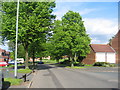
Staple Lodge Road
Spring greenery and sunshine on this modern housing development.
Image: © David Stowell
Taken: 26 May 2006
0.18 miles
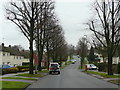
2
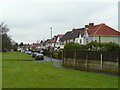
Inter-war housing on West Heath Road
Looking north towards Turves Green.
Image: © Jonathan Billinger
Taken: 28 Jan 2009
0.20 miles
3
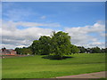
Recreation ground at Staple Lodge Road
The open green area and playing fields to the south of Staple Lodge Road.
Image: © David Stowell
Taken: 26 May 2006
0.20 miles
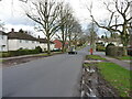
5
Staple Lodge Road, Turves Green
Looking east towards King's Norton (with apostrophe).
Image: © Jonathan Billinger
Taken: 28 Jan 2009
0.22 miles
6
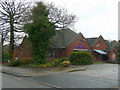
The Fordrough
A modern pub at the junction of The Fordrough and West Heath Road.
The gridline splits the building - the side facing is in SP0278.
Image: © Jonathan Billinger
Taken: 28 Jan 2009
0.22 miles
