IMAGES TAKEN NEAR TO
Daffodil Way, BIRMINGHAM, B31 2YU
Introduction
This page details the photographs taken nearby to Daffodil Way, B31 2YU by members of the Geograph project.
The Geograph project started in 2005 with the aim of publishing, organising and preserving representative images for every square kilometre of Great Britain, Ireland and the Isle of Man.

There are currently over 7.5m images from over14,400 individuals and you can help contribute to the project by visiting https://www.geograph.org.uk
Image Map
Images are licensed for reuse under creativecommons.org/licenses/by-sa/2.0
Notes
- Clicking on the map will re-center to the selected point.
- The higher the marker number, the further away the image location is from the centre of the postcode.
Image Listing (68 Images Found)
Images are licensed for reuse under creativecommons.org/licenses/by-sa/2.0
Image
Details
Distance
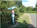
1
Entrance to Daffodil Park, Tessall Lane, Longbridge, Birmingham
It is part of National Cycle Route 5 allowing you to bypass the busy Bristol Road South on the way to the city centre. It follows the River Rea into Northfield.
Image: © Jeff Gogarty
Taken: 23 Sep 2015
0.07 miles
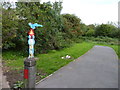
2
Cycle Route 5 sign at Tessall Lane junction with Rea Valley path, Longbridge
Image: © Ruth Sharville
Taken: 5 Aug 2022
0.07 miles
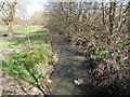
3
River Rea From Tessall Lane Bridge
The river has just emerged from the underground culvert taking it from by the old B.R. ticket office on Bristol Road South and under the Rover works.
Image: © Roy Hughes
Taken: 31 Mar 2009
0.09 miles
4
River Rea from Tessall Lane, Longbridge, Birmingham
On the left bank is Daffodil Park.
Image: © Jeff Gogarty
Taken: 29 Mar 2016
0.09 miles
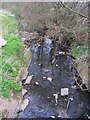
5
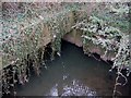
River Rea Culvert Exit , Tessall Lane Bridge.
The river has just passed under the Rover works after entering the culvert by the old B.R. ticket office on Bristol Road South Image
Image: © Roy Hughes
Taken: 31 Mar 2009
0.10 miles
6
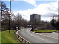
Tessall Lane bridge over the River Rea, Longbridge, Birmingham
Image: © Jeff Gogarty
Taken: 29 Mar 2016
0.12 miles
7

Tessall Lane over the River Rea, Longbridge
The lane leads to the Rea Valley Walk. The main railway line runs the other side of the fence.
Image: © Ruth Sharville
Taken: 5 Aug 2022
0.12 miles
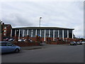
8
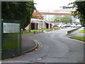
Entrance to Austin Sports and Social Club, Longbridge
The Austin works may have gone but the social club is still going strong. The new developments, e.g. Premier Inn, that have risen on the old Rover site can be seen at the other side of the car park.
Image: © Jeff Gogarty
Taken: 23 Sep 2015
0.12 miles
9
Riverpark Way, Northfield, Birmingham
Latest and probably the last development on the former Kalamazoo site. This is just about on the boundary between Northfield and Longbridge.
Taken from the 'riverpark' also known as Daffodil Park.
Image: © Jeff Gogarty
Taken: 23 Sep 2015
0.13 miles
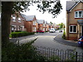
10
Back of job centre, Tessall Lane, Longbridge, Birmingham
The main entrance is at 1300 Bristol Road South
Image: © Jeff Gogarty
Taken: 23 Sep 2015
0.13 miles