IMAGES TAKEN NEAR TO
Mavis Road, BIRMINGHAM, B31 2SD
Introduction
This page details the photographs taken nearby to Mavis Road, B31 2SD by members of the Geograph project.
The Geograph project started in 2005 with the aim of publishing, organising and preserving representative images for every square kilometre of Great Britain, Ireland and the Isle of Man.

There are currently over 7.5m images from over14,400 individuals and you can help contribute to the project by visiting https://www.geograph.org.uk
Image Map
Images are licensed for reuse under creativecommons.org/licenses/by-sa/2.0
Notes
- Clicking on the map will re-center to the selected point.
- The higher the marker number, the further away the image location is from the centre of the postcode.
Image Listing (41 Images Found)
Images are licensed for reuse under creativecommons.org/licenses/by-sa/2.0
Image
Details
Distance
1
Did a road continue?
As this is opposite Bodenham Road at the other side of the A38 it is possible the road continued before being cut by the trunk road.
Image: © Jeff Gogarty
Taken: 7 Mar 2016
0.04 miles
2
Riverpark Way, Northfield, Birmingham
Latest and probably the last development on the former Kalamazoo site. This is just about on the boundary between Northfield and Longbridge.
Taken from the 'riverpark' also known as Daffodil Park.
Image: © Jeff Gogarty
Taken: 23 Sep 2015
0.07 miles
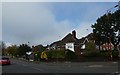
3
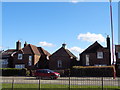
Unusual houses on the A38 near Longbridge, Birmingham
Image: © Jeff Gogarty
Taken: 7 Mar 2016
0.09 miles

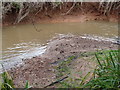
5
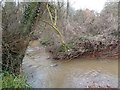
Deposition and erosion (4)
Just down stream from Image The dead tree across has been totally undercut and is only being held up by the branches being intertwined with the larger tree.
Image: © Jeff Gogarty
Taken: 10 Mar 2016
0.12 miles
6
Bodenham Road, Longbridge
A suburban road off the A38
Image: © David Smith
Taken: 23 Oct 2019
0.12 miles
7

Avondale Court, Bristol Road South, Northfield, Birmingham
Rear view from Reynolds and Reynolds Offices.
Image: © Jeff Gogarty
Taken: 25 Sep 2015
0.13 miles
8
Bend in the River Rea between Longbridge and Northfield
This shows clearly on a small scale movement of a river course. Under cutting the bank on the outside while depositing silt on the inside.
Image: © Jeff Gogarty
Taken: 23 Sep 2015
0.13 miles
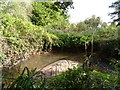
9
Deposition and erosion (2)
As in Image a loop of the River Rea shows deposition and erosion. The whole land in the foreground has been deposited at the inside of the bend. The erosion over the last few years has been great but it has currently slowed due to the inside curve having a harder rock rather than sand and gravel as previously. The erosion had speeded up after the partial dam diverting water down the mill race broke leaving that silted up and all the water coming around the loops.
Image: © Jeff Gogarty
Taken: 10 Mar 2016
0.13 miles
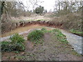
10
Deposition and erosion (3)
A closer look at Image where the more recent deposit can be seen. This is a place of very rapid deposition as during flooding soil being brought down a more rapid stretch reaches a flatter part. All the silt shown here has been deposited in the last few years even the part being grassed over.
Image: © Jeff Gogarty
Taken: 10 Mar 2016
0.13 miles