IMAGES TAKEN NEAR TO
William Road, BIRMINGHAM, B31 2PX
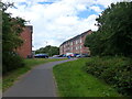
Introduction
This page details the photographs taken nearby to William Road, B31 2PX by members of the Geograph project.
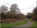
The Geograph project started in 2005 with the aim of publishing, organising and preserving representative images for every square kilometre of Great Britain, Ireland and the Isle of Man.

There are currently over 7.5m images from over14,400 individuals and you can help contribute to the project by visiting https://www.geograph.org.uk
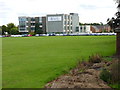
Image Map
Images are licensed for reuse under creativecommons.org/licenses/by-sa/2.0
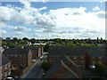
Notes
- Clicking on the map will re-center to the selected point.
- The higher the marker number, the further away the image location is from the centre of the postcode.
Image Listing (62 Images Found)
Images are licensed for reuse under creativecommons.org/licenses/by-sa/2.0
Image
Details
Distance
1

Rea Road, Northfield, Birmingham
Recent development on former site of Kalamazoo business park.
Image: © Jeff Gogarty
Taken: 23 Sep 2015
0.03 miles
2

Three layers of buildings, Northfield, Birmingham
The nearest building is a workshop on Mill Walk, followed by Houses on Rea Road and finally the offices of Reynolds & Reynolds on Bristol Road South.
Image: © Jeff Gogarty
Taken: 8 Mar 2016
0.04 miles
3
Housing on the former site of Kalamzoo business park
Where the houses in the foreground end there is the River Rea and then the New Street to Longbridge railway line. In the distance is Turves Green another suburb of Birmingham.
Image: © Jeff Gogarty
Taken: 24 Sep 2015
0.05 miles
4
Reynolds and Reynolds European Headquarters
This is the last remaining building standing from the former Kalamazoo site. Now owned by a US computer software company. The grounds in front of the buildings are used as the sports field of the local schools.
Image: © Jeff Gogarty
Taken: 23 Sep 2015
0.07 miles
5
The Rea Valley cycle route 5 approaches Rea Road, Longbridge
Cycle Route 5 follows the valley of this stream here.
Image: © Ruth Sharville
Taken: 5 Aug 2022
0.08 miles
6

From North Worcestershire Golf Club
Looking over Northfield to High Hill.
Image: © Jeff Gogarty
Taken: 30 Mar 2016
0.08 miles
7
Path through Daffodil Park, Longbridge, Birmingham
This is part of National Cycle Route 5 and is at the opposite end of the park to Image The River Rea is in the trees on the left.
Image: © Jeff Gogarty
Taken: 10 Mar 2016
0.08 miles
8
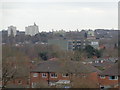
Over the rooftops to Reynolds & Reynolds and beyond
Taken from Allens Cross Park, Northfield, Birmingham.
The office block in the mid-ground is Reynolds & Reynolds (formerly Kalamazoo Computer Group). The white tower blocks are Risborough House, Manderville House and Wendover House. I have not located the other tower blocks.
Image: © Jeff Gogarty
Taken: 21 Mar 2016
0.09 miles
9
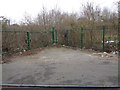
Contaminated land becomes wood
The strip of land between the River Rea and the railway next to Rea Road in Northfield was planted with trees and mainly left to nature. This is where the original Kalamazoo factory stood until it was demolished leaving contaminated land. Where the rest of the Kalamazoo site is now housing this strip could not be redeveloped.
Image: © Jeff Gogarty
Taken: 8 Mar 2016
0.10 miles
10
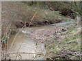
Deposition and erosion (1)
The River Rhea as it goes through Daffodil Park, Longbridge shows deposition and erosion at a rapid rate. The river quickly swells during rain and brings gravel down the river which is deposited on the inside of the curves. When the river level drops this can be seen as in this picture. The bank on the outside has been cut away but this can not be seen due to the brambles.
Image: © Jeff Gogarty
Taken: 10 Mar 2016
0.10 miles