IMAGES TAKEN NEAR TO
Masefield Square, BIRMINGHAM, B31 2HL
Introduction
This page details the photographs taken nearby to Masefield Square, B31 2HL by members of the Geograph project.
The Geograph project started in 2005 with the aim of publishing, organising and preserving representative images for every square kilometre of Great Britain, Ireland and the Isle of Man.

There are currently over 7.5m images from over14,400 individuals and you can help contribute to the project by visiting https://www.geograph.org.uk
Image Map
Images are licensed for reuse under creativecommons.org/licenses/by-sa/2.0
Notes
- Clicking on the map will re-center to the selected point.
- The higher the marker number, the further away the image location is from the centre of the postcode.
Image Listing (13 Images Found)
Images are licensed for reuse under creativecommons.org/licenses/by-sa/2.0
Image
Details
Distance
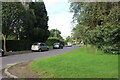
2
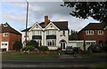
Bunbury Rd Northfield.
This is a long residential road of large modern detached houses. It is also the B4121 and it runs west from Northfield to Cotteridge.
Image: © Nigel Mykura
Taken: 19 Feb 2011
0.08 miles
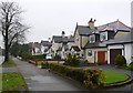
7
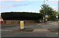
Interesting hedge on Hole Lane, Northfield
Image: © David Howard
Taken: 8 Aug 2021
0.17 miles
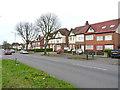
8
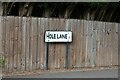
Sign for Hole Lane, Northfield
This is one of the names I would take if I was offered a road name to live on.
Image: © David Howard
Taken: 8 Aug 2021
0.18 miles
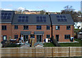
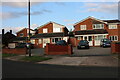
9
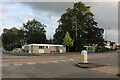
Bunbury Road, Northfield
At the end of Hole Lane.
Image: © David Howard
Taken: 8 Aug 2021
0.18 miles