IMAGES TAKEN NEAR TO
Somerdale Road, BIRMINGHAM, B31 2EG
Introduction
This page details the photographs taken nearby to Somerdale Road, B31 2EG by members of the Geograph project.
The Geograph project started in 2005 with the aim of publishing, organising and preserving representative images for every square kilometre of Great Britain, Ireland and the Isle of Man.

There are currently over 7.5m images from over14,400 individuals and you can help contribute to the project by visiting https://www.geograph.org.uk
Image Map
Images are licensed for reuse under creativecommons.org/licenses/by-sa/2.0
Notes
- Clicking on the map will re-center to the selected point.
- The higher the marker number, the further away the image location is from the centre of the postcode.
Image Listing (11 Images Found)
Images are licensed for reuse under creativecommons.org/licenses/by-sa/2.0
Image
Details
Distance
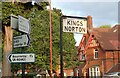
1
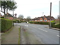
Road junction in Cotteridge
Woodlands Park Road runs left-right across the photo, with Somerdale Road on the far side of the junction, and the photographer position is in Kingsley Road.
Image: © Richard Law
Taken: 8 Jan 2020
0.04 miles
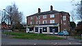
2
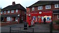
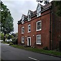
Heath Road Post Office
There has been a post office here since at least the 1930s.
Image: © Paul Collins
Taken: 18 Mar 2017
0.10 miles
3
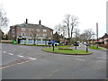
Flats and shops to let in Cotteridge
The large building on the far side of the roundabout consists of a number of retail units on the ground floor with flats above; the 'To Let' sign implies that the units at least are currently empty.
Image: © Richard Law
Taken: 8 Jan 2020
0.10 miles
4
Vacant Shops on Woodlands Park Road
The larger shop on the right of the view was latterly a convenience store but both shops are vacant in March 2017, despite a prominent location at a junction and having easy parking.
Image: © Paul Collins
Taken: 18 Mar 2017
0.12 miles
5
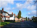
Northfield Rd
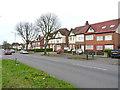
This is a long curving road of 1930's semi detached houses that runs off and then parallel to Middleton Hall Rd
Image: © Nigel Mykura
Taken: 8 Jan 2011
0.15 miles
7
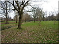
Woodlands Park in Cotteridge
An area of green space in Birmingham, stretching between Northfield and Bournville. Nothing of it is really visible in this photo, but on the left there is an area of ground recorded as 'Burnt Mound' by an archaeological survey in the early 1980s, after the stream exposed a section of heat-damaged stones and charcoal, believed to be roughly 3000 years old https://historicengland.org.uk/listing/the-list/list-entry/1020540
Image: © Richard Law
Taken: 8 Jan 2020
0.20 miles
9
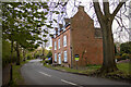
Hole Farm, Hole Lane
This farmhouse is a survival from old rural Northfield amidst the housing around Bournville.
Image: © A J Paxton
Taken: 16 Sep 2023
0.22 miles