IMAGES TAKEN NEAR TO
Bunbury Road, BIRMINGHAM, B31 2DR
Introduction
This page details the photographs taken nearby to Bunbury Road, B31 2DR by members of the Geograph project.
The Geograph project started in 2005 with the aim of publishing, organising and preserving representative images for every square kilometre of Great Britain, Ireland and the Isle of Man.

There are currently over 7.5m images from over14,400 individuals and you can help contribute to the project by visiting https://www.geograph.org.uk
Image Map
Images are licensed for reuse under creativecommons.org/licenses/by-sa/2.0
Notes
- Clicking on the map will re-center to the selected point.
- The higher the marker number, the further away the image location is from the centre of the postcode.
Image Listing (7 Images Found)
Images are licensed for reuse under creativecommons.org/licenses/by-sa/2.0
Image
Details
Distance
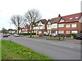
2
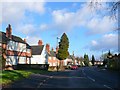
Northfield Rd
This is a long curving road of 1930's semi detached houses that runs off and then parallel to Middleton Hall Rd
Image: © Nigel Mykura
Taken: 8 Jan 2011
0.12 miles
3
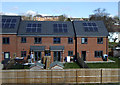
New Houses Being Built Longfellow Road Northfield
Image: © Roy Hughes
Taken: 26 Sep 2015
0.14 miles
6
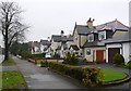
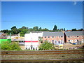
Bunbury Rd Northfield.
This is a long residential road of large modern detached houses. It is also the B4121 and it runs west from Northfield to Cotteridge.
Image: © Nigel Mykura
Taken: 19 Feb 2011
0.19 miles
7
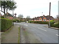
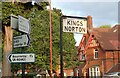
Road junction in Cotteridge
Woodlands Park Road runs left-right across the photo, with Somerdale Road on the far side of the junction, and the photographer position is in Kingsley Road.
Image: © Richard Law
Taken: 8 Jan 2020
0.19 miles