IMAGES TAKEN NEAR TO
Hole Lane, BIRMINGHAM, B31 2DG
Introduction
This page details the photographs taken nearby to Hole Lane, B31 2DG by members of the Geograph project.
The Geograph project started in 2005 with the aim of publishing, organising and preserving representative images for every square kilometre of Great Britain, Ireland and the Isle of Man.

There are currently over 7.5m images from over14,400 individuals and you can help contribute to the project by visiting https://www.geograph.org.uk
Image Map
Images are licensed for reuse under creativecommons.org/licenses/by-sa/2.0
Notes
- Clicking on the map will re-center to the selected point.
- The higher the marker number, the further away the image location is from the centre of the postcode.
Image Listing (24 Images Found)
Images are licensed for reuse under creativecommons.org/licenses/by-sa/2.0
Image
Details
Distance
1
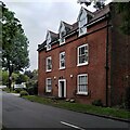
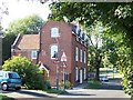
Hole Farm, Hole Lane
This farmhouse is a survival from old rural Northfield amidst the housing around Bournville.
Image: © A J Paxton
Taken: 16 Sep 2023
0.13 miles
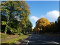
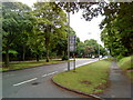
4
Junction of Bristol Road South and Hole Lane
Image: © Andrew Abbott
Taken: 29 May 2010
0.19 miles
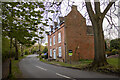
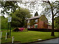
5
Hole Farm, Northfield
No farming here for many a year. Most of the surrounding land is occupied by the Bournville housing estate.
Image: © Adrian Bailey
Taken: 17 Aug 2005
0.19 miles
7
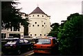
Royal Orthopaedic Hospital
The Royal Orthopaedic Hospital in Northfield, Birmingham, pictured in August 1999.
Image: © Ruth Riddle
Taken: Unknown
0.20 miles
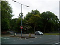
10
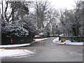
Hole Lane Northfield.
Hole Lane at the junction with the A38 Bristol Road South.
Image: © Roy Hughes
Taken: 3 Feb 2009
0.22 miles