IMAGES TAKEN NEAR TO
Heath Road South, BIRMINGHAM, B31 2BB
Introduction
This page details the photographs taken nearby to Heath Road South, B31 2BB by members of the Geograph project.
The Geograph project started in 2005 with the aim of publishing, organising and preserving representative images for every square kilometre of Great Britain, Ireland and the Isle of Man.

There are currently over 7.5m images from over14,400 individuals and you can help contribute to the project by visiting https://www.geograph.org.uk
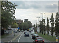
Image Map
Images are licensed for reuse under creativecommons.org/licenses/by-sa/2.0
Notes
- Clicking on the map will re-center to the selected point.
- The higher the marker number, the further away the image location is from the centre of the postcode.
Image Listing (24 Images Found)
Images are licensed for reuse under creativecommons.org/licenses/by-sa/2.0
Image
Details
Distance
2
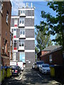
Telephone Exchange, Northfield (3)
This photo shows the old redbrick building on the left and the extension behind it with the double doors on each floor for delivery of TE equipment and mobile phone aerials on the roof. Rubbish bins and BT Openreach vans can also be seen in this photo.
Image: © David Hillas
Taken: 1 Sep 2011
0.14 miles
3
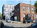
Telephone Exchange, Northfield (2)
This photo shows both the old redbrick TE and the extension behind it in Meeting House Lane. Besides Northfield, this TE also serves Bartley Green, Longbridge, Turves Green and Weoley Castle (part) nearby.
Image: © David Hillas
Taken: 1 Sep 2011
0.14 miles
4
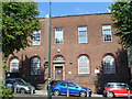
Telephone Exchange, Northfield (1)
Situated on the B4121 Church Road, this TE would appear to date from the 1930s. It used to have PRIory numbers until the late 1960s. Now it has 0121-411, 475, 476, 477, 478, 482 and 483 xxxx numbers. The postcode of this TE is B31 2LD.
Image: © David Hillas
Taken: 1 Sep 2011
0.15 miles
5
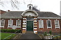
Northfield Library
Erected by the Kings Norton and Northfield Urban District Council in 1906 from funds provided by Andrew Carnegie on land given by George Cadbury.
It was rebuilt by the City of Birmingham Free Libraries Committee in 1914 after destruction by arson caused by Suffragettes in 1912.
Charles Edward Bateman and Alfred Hale, Architects.
Image: © Andrew Abbott
Taken: 29 Apr 2018
0.15 miles
6
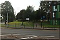
Banbury Road at the corner of Church Road
The YMCA is on the right
Image: © David Howard
Taken: 8 Aug 2021
0.17 miles
7
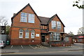
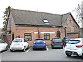
Northfield Adult Education Centre
Run by Birmingham Adult Education Service.
Image: © Andrew Abbott
Taken: 29 Apr 2018
0.17 miles
10
The (former) outhouse to the Rectory, Northfield
This building, of which the half-timbered portion on the right is probably 16th century, and the brick-built portion on the left dates more to the 18th, was once an outhouse to the nearby Rectory. It was converted to garages, and now appears to be in use as offices. The whole structure was Grade II listed https://britishlistedbuildings.co.uk/101220878-outhouse-to-the-rectory-now-garages-between-the-rectory-and-the-pastoral-centre-northfield-ward#.XyLdTyhKjcs & https://historicengland.org.uk/listing/the-list/list-entry/1220878 in 1982.
Image: © Richard Law
Taken: 8 Jan 2020
0.23 miles