IMAGES TAKEN NEAR TO
Cheverton Road, BIRMINGHAM, B31 1RU
Introduction
This page details the photographs taken nearby to Cheverton Road, B31 1RU by members of the Geograph project.
The Geograph project started in 2005 with the aim of publishing, organising and preserving representative images for every square kilometre of Great Britain, Ireland and the Isle of Man.

There are currently over 7.5m images from over14,400 individuals and you can help contribute to the project by visiting https://www.geograph.org.uk
Image Map
Images are licensed for reuse under creativecommons.org/licenses/by-sa/2.0
Notes
- Clicking on the map will re-center to the selected point.
- The higher the marker number, the further away the image location is from the centre of the postcode.
Image Listing (2 Images Found)
Images are licensed for reuse under creativecommons.org/licenses/by-sa/2.0
Image
Details
Distance
1
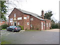
Crossway Church, Northfield
A charity-funded church on St Heliers Road in Northfield.
Image: © Richard Law
Taken: 8 Jan 2020
0.09 miles
2
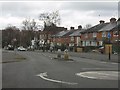
Hoggs Lane at Barnsdale Crescent
One of several mini-roundabouts on Hoggs Lane, with characteristic housing for the area in view, plus local shops ahead on the right.
Image: © Peter Whatley
Taken: 10 Mar 2012
0.22 miles