IMAGES TAKEN NEAR TO
Draycott Drive, BIRMINGHAM, B31 1DW
Introduction
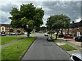
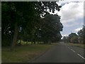
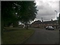
This page details the photographs taken nearby to Draycott Drive, B31 1DW by members of the Geograph project.
The Geograph project started in 2005 with the aim of publishing, organising and preserving representative images for every square kilometre of Great Britain, Ireland and the Isle of Man.

There are currently over 7.5m images from over14,400 individuals and you can help contribute to the project by visiting https://www.geograph.org.uk
Image Map
Images are licensed for reuse under creativecommons.org/licenses/by-sa/2.0
Notes
- Clicking on the map will re-center to the selected point.
- The higher the marker number, the further away the image location is from the centre of the postcode.
Image Listing (15 Images Found)
Images are licensed for reuse under creativecommons.org/licenses/by-sa/2.0
Image
Details
Distance
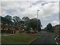
2
Dunchurch Drive
Taken from the top of the X21 bus.
Image: © Andrew Abbott
Taken: 14 Jul 2024
0.03 miles
8
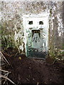
Flush bracket S3069 - Shendley Hill trig
Visible after a little bit of excavation with a stick and the toe of my boot; the flush bracket was installed in 1943, and levelled in 1956 at 200.649m above Ordnance Datum Newlyn.
Image: © Richard Law
Taken: 8 Jan 2020
0.21 miles