IMAGES TAKEN NEAR TO
Parsons Hill, BIRMINGHAM, B30 3PN
Introduction
This page details the photographs taken nearby to Parsons Hill, B30 3PN by members of the Geograph project.
The Geograph project started in 2005 with the aim of publishing, organising and preserving representative images for every square kilometre of Great Britain, Ireland and the Isle of Man.

There are currently over 7.5m images from over14,400 individuals and you can help contribute to the project by visiting https://www.geograph.org.uk
Image Map
Images are licensed for reuse under creativecommons.org/licenses/by-sa/2.0
Notes
- Clicking on the map will re-center to the selected point.
- The higher the marker number, the further away the image location is from the centre of the postcode.
Image Listing (33 Images Found)
Images are licensed for reuse under creativecommons.org/licenses/by-sa/2.0
Image
Details
Distance
1
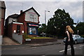
Birmingham : Baldwin Road
A corner shop can be seen on the corner of Baldwin Road.
Image: © Lewis Clarke
Taken: 1 Jul 2015
0.08 miles
2
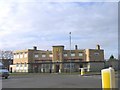
McDonald's, Parsons Hill .
This fast food restaurant is situated in the art deco building that was once home to the Cartland Arms public house. The pub was named after the local family which owned land in the area. At least this fine building is still standing and being cared for.
Image: © Roy Hughes
Taken: 20 Feb 2009
0.09 miles
3

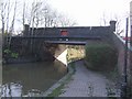
Wharf Road, King's Norton
Looking towards Parson's Hill from the bridge over the Worcester & Birmingham Canal.
Image: © Stephen McKay
Taken: 9 Apr 2016
0.12 miles
4

Zebra crossing, Parsons Hill, King's Heath
Three icons of the past gradually disappearing from our streets - the corner shop, a red telephone kiosk and a Zebra crossing.
Image: © David Stowell
Taken: 26 May 2006
0.12 miles
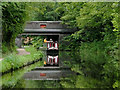
5
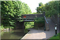
King's Norton Bridge No 71
On the Birmingham and Worcester Canal.
Image: © John M
Taken: 6 Feb 2008
0.12 miles
6

Roundabout at the western end of Bell's Lane
Parson's Hill goes off to the left here, with Broadmeadow Lane just to the right of the large Maccy D's, and the white lorry entering the roundabout via Monyhull Hall Road.
Image: © Richard Law
Taken: 29 Jan 2020
0.12 miles
8
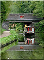
Parson's Hill Bridge near Kings Norton, Birmingham
Parson's Hill Bridge near Kings Norton, Birmingham
Bridge No 71 on the Worcester and Birmingham Canal.
The Worcester and Birmingham Canal was constructed in stages between 1791 and 1815. Grain, timber and agricultural produce were carried to the Midlands. Industrial goods and coal were carried down towards Worcester, often for onward transport to Bristol. Pairs of donkeys were often used in preference to horses, maybe because they could easily be put onto the boats which had to be legged through the tunnels near Birmingham.
Image: © Roger D Kidd
Taken: 25 Aug 2010
0.13 miles
9
Parson's Hill Bridge near Kings Norton, Birmingham
Bridge No 71 on the Worcester and Birmingham Canal.
The Worcester and Birmingham Canal was constructed in stages between 1791 and 1815. Grain, timber and agricultural produce were carried to the Midlands. Industrial goods and coal were carried down towards Worcester, often for onward transport to Bristol. Pairs of donkeys were often used in preference to horses, maybe because they could easily be put onto the boats which had to be legged through the tunnels near Birmingham.
Image: © Roger D Kidd
Taken: 25 Aug 2010
0.13 miles
10
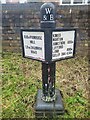
Distance Marker, Worcester and Birmingham Canal
On the Towpath near bridge 71, Wharf Road. An alternative view looking South is Image
Inscription: W / & B // 800m Primrose / Hill / 1.2km Shannon Road //
Kings / Norton / Junction 400m / Lifford / Lane 800m / Selly Oak 4.5km
Milestoned Society National ID:
Image: © Billy Hufton
Taken: 4 Jan 2025
0.13 miles