IMAGES TAKEN NEAR TO
Pershore Road South, BIRMINGHAM, B30 3EX
Introduction
This page details the photographs taken nearby to Pershore Road South, B30 3EX by members of the Geograph project.
The Geograph project started in 2005 with the aim of publishing, organising and preserving representative images for every square kilometre of Great Britain, Ireland and the Isle of Man.

There are currently over 7.5m images from over14,400 individuals and you can help contribute to the project by visiting https://www.geograph.org.uk
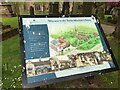
Image Map
Images are licensed for reuse under creativecommons.org/licenses/by-sa/2.0
Notes
- Clicking on the map will re-center to the selected point.
- The higher the marker number, the further away the image location is from the centre of the postcode.
Image Listing (69 Images Found)
Images are licensed for reuse under creativecommons.org/licenses/by-sa/2.0
Image
Details
Distance
1

'The Green', Kings Norton
The road upon which the cars are parked is known as 'The Green'
Image: © Rob Newman
Taken: 5 Mar 2013
0.03 miles

5
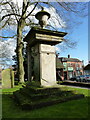
The Middlemore Monument in Kings Norton
Situated in the churchyard of St Nicholas, this stone monument dates from 1770 and commemorates a number of members of the Middlemore family who lived in the area; some of the names are no longer legible, and two of the corner columns have collapsed. It was Grade II listed https://britishlistedbuildings.co.uk/101075550-monument-to-the-south-of-the-church-of-st-nicholas-and-facing-the-green-kings-norton-ward#.YIs0mrVKhPY & https://historicengland.org.uk/listing/the-list/list-entry/1075550 in 1982.
Image: © Richard Law
Taken: 26 Feb 2020
0.04 miles
6
Tudor Merchant's House, King's Norton
The information board reads "A high status Tudor House, a Pub, a Grocer's shop and a community meeting place; the Tudor Merchant's House has played its part in Birmingham's history for over 500 years.
Saint Nicholas Place is the city's largest collection of Medieval buildings includes St Nicholas Church, the Tudor Merchant's House and the Old Grammar School"
Image: © Michael Westley
Taken: 2 May 2022
0.04 miles
7
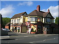
The Navigation, King's Norton
This public house is in Wharf Lane which not surprisingly leads to the Worcester & Birmingham Canal. Up until the 1930s a cattle market was regularly held in what is now the pub car park. In those days this was a rather more rural area than today!
Image: © David Stowell
Taken: 26 May 2006
0.04 miles
8
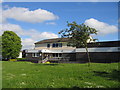
King's Norton Police Station
Beside Wharf Lane, opposite the Navigation Inn.
Image: © David Stowell
Taken: 26 May 2006
0.04 miles
9

The Graveyard beside St Nicolas Church, Kings Norton
Image: © Rob Newman
Taken: 5 Mar 2013
0.05 miles