IMAGES TAKEN NEAR TO
Breedon Way, BIRMINGHAM, B30 3AT
Introduction
This page details the photographs taken nearby to Breedon Way, B30 3AT by members of the Geograph project.
The Geograph project started in 2005 with the aim of publishing, organising and preserving representative images for every square kilometre of Great Britain, Ireland and the Isle of Man.

There are currently over 7.5m images from over14,400 individuals and you can help contribute to the project by visiting https://www.geograph.org.uk
Image Map
Images are licensed for reuse under creativecommons.org/licenses/by-sa/2.0
Notes
- Clicking on the map will re-center to the selected point.
- The higher the marker number, the further away the image location is from the centre of the postcode.
Image Listing (67 Images Found)
Images are licensed for reuse under creativecommons.org/licenses/by-sa/2.0
Image
Details
Distance
1
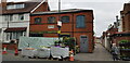
Former Factory Site
This image was captured from the River Rea Cycleroute and looks west to the shops along Pershore Road. It shows a view across the cleared site of what was originally a large brush factory and later Wilmott Breeden, who were a significant manufacturer of components such as chromed car bumpers. The site seems likely to be regenerated shortly with plans to build about 105 homes being discussed.
Image: © Paul Collins
Taken: 14 Dec 2016
0.03 miles
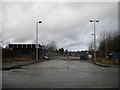
2
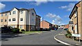
Iron Way, Stirchley
The new housing has recently been built on a former factory site, bringing to a close more than a decade of uncertainty and legal/planning disagreements about what supermarket(s) and/or housing to build on this site and others nearby. Iron Way is a new road, being an extension of Mayfield Road which was formerly a very short cul-de-sac. Bollards still separate the two roads.
Image: © Paul Collins
Taken: 26 Jul 2024
0.04 miles
3
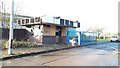
Former Factory Gateway
This is the Fordhouse Lane entrance to what was originally a large brush factory and later Wilmott Breeden, who were a significant manufacturer of components such as chromed car bumpers. The site was largely cleared some years ago and a council office now occupies part of it. The rest of the site lies vacant but seems likely to be regenerated shortly with plans to build about 105 homes being discussed.
Image: © Paul Collins
Taken: 14 Dec 2016
0.05 miles
4
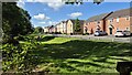
Nine Elms Road and Balancing Pond, Stirchley
The road, balancing pond and new housing have recently been built on a former factory site bringing to a close more than a decade of uncertainty and legal/planning disagreements about what supermarket(s) and/or housing to build on this site and others nearby.
Image: © Paul Collins
Taken: 26 Jul 2024
0.07 miles
5
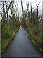
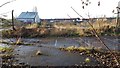
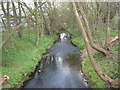
River Rea running north through Stirchley
Little (apart from a couple of trees falling) has changed in the last 10 years since Image was taken.
Image: © Richard Law
Taken: 16 Dec 2019
0.08 miles
7
Former factory gates, Fordhouse Lane, Stirchley
The car parts factory beyond the gates (where my father worked for a while) appears to have been demolished only recently.
Image: © Richard Vince
Taken: 10 Mar 2018
0.08 miles
8
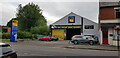
Wards on Pershore Road, Stirchley
Wards sell plants, fruit and vegetables.
Image: © Paul Collins
Taken: 15 Jul 2021
0.09 miles
9
River Rea From Fordhouse Lane, Breedon Cross.
Image: © Roy Hughes
Taken: 7 Apr 2009
0.09 miles
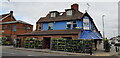
10
Jesse Hill, Gunmaker
Jesse Hill has been making guns here for over 40 years. The plants are stock overspill from Ward's greengrocers, adjacent.
Image: © Paul Collins
Taken: 15 Jul 2021
0.10 miles