IMAGES TAKEN NEAR TO
Uffculme Road, BIRMINGHAM, B30 2TR
Introduction
This page details the photographs taken nearby to Uffculme Road, B30 2TR by members of the Geograph project.
The Geograph project started in 2005 with the aim of publishing, organising and preserving representative images for every square kilometre of Great Britain, Ireland and the Isle of Man.

There are currently over 7.5m images from over14,400 individuals and you can help contribute to the project by visiting https://www.geograph.org.uk
Image Map
Images are licensed for reuse under creativecommons.org/licenses/by-sa/2.0
Notes
- Clicking on the map will re-center to the selected point.
- The higher the marker number, the further away the image location is from the centre of the postcode.
Image Listing (18 Images Found)
Images are licensed for reuse under creativecommons.org/licenses/by-sa/2.0
Image
Details
Distance
1
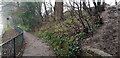
Dad's Lane Pavement with Midland Railway Marker Post
This is the view down Dad's Lane from the railway bridge, taken on a gloomy midwinter's day. Highbury Park is at the top of the bank and because there are no steps at this point people risk a fall ascending or descending the slippery bank. The MR on the metal marker post is presumably a boundary marker signifying 'Midland Railway', so it presumably dates to before amalgamation in 1922.
Image: © Paul Collins
Taken: 26 Dec 2021
0.05 miles
2
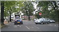
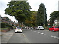
Dad's Lane / Shutlock Lane junction
Entrance to Highbury Park is just a short distance along Shutlock Lane on the right (beyond where cars are coming out). The railway bridge is just behind the photographer's position.
Image: © Michael Westley
Taken: 15 Oct 2010
0.06 miles
3
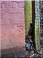
OS benchmark - King's Heath, Avenue Road railway bridge
An OS cutmark on the bridge buttress, NE side of the road. Levelled in 1965 at 141.647m above Ordnance Datum Newlyn.
Image: © Richard Law
Taken: 16 Dec 2019
0.07 miles
4
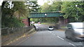
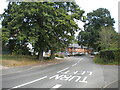
Dad's Lane / Avenue Road railway bridge
Between Cartland Road and King's Heath, the freight line crosses this road. King's Heath Park is to the left of photo position, Highbury Park is beyond the bridge on the right.
Image: © Michael Westley
Taken: 15 Oct 2010
0.08 miles
5
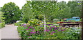
Television Garden, Kings Heath Park
A fenced off area of Kings Heath Park was used to make gardening shows for TV. It has also been used for horticulture students and is sometimes open to the public. See https://www.birmingham.gov.uk/info/20089/parks/1679/kings_heath_park/5
Image: © Paul Collins
Taken: 10 May 2020
0.09 miles
6
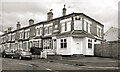
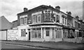
Former Corner Shop, Station Road
Pauls's News & Store is no longer in business at the end of Station Road.
Image: © Des Blenkinsopp
Taken: 26 Apr 2023
0.13 miles
9
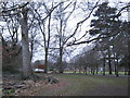
Highbury Park, Kings Heath
View of trail through trees, looking across park towards Shutlock Lane.
http://highburyparkfriends.org.uk/wp/?page_id=7
Image: © Michael Westley
Taken: 17 Mar 2011
0.18 miles
10
The Gentleman's Barber Shop
An old corner shop, most recently a barber shop, but now closed.
Image: © Des Blenkinsopp
Taken: 26 Apr 2023
0.18 miles