IMAGES TAKEN NEAR TO
Pineapple Road, BIRMINGHAM, B30 2TB
Introduction
This page details the photographs taken nearby to Pineapple Road, B30 2TB by members of the Geograph project.
The Geograph project started in 2005 with the aim of publishing, organising and preserving representative images for every square kilometre of Great Britain, Ireland and the Isle of Man.

There are currently over 7.5m images from over14,400 individuals and you can help contribute to the project by visiting https://www.geograph.org.uk
Image Map
Images are licensed for reuse under creativecommons.org/licenses/by-sa/2.0
Notes
- Clicking on the map will re-center to the selected point.
- The higher the marker number, the further away the image location is from the centre of the postcode.
Image Listing (9 Images Found)
Images are licensed for reuse under creativecommons.org/licenses/by-sa/2.0
Image
Details
Distance
1
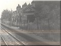
Hazelwell Station, near Kings Heath, Birmingham
During early days of Birmingham's Cross-city rail service, many trains from Longbridge would go directly from Kings Norton to New Street via the freight line through Kings Heath. This enabled additional rolling stock to reach Birmingham without stacking up through Bournville and University.
The benefit to us railway photographers were rare views of former passenger stations on this ex-Midland Railway route. Hazelwell Station, closed in 1941, the southern platform and buildings are in this photo, was accessed from Cartland Road, situated between Kings Heath and Kings Norton. These buildings have since been dismantled.
The good news is the line is hoped to be reopened in future to passengers, when funding arrives for a new loop line to take trains to Bordesley and Moor Street instead of through St Andrews junction to New Street.
Image: © Michael Westley
Taken: Unknown
0.15 miles
2
King Edward's School
Boys' School (Camp Hill), backing onto King's Heath Park, accessed from Vicarage Road.
http://web.camphillboys.bham.sch.uk/
Image: © Michael Westley
Taken: 21 Mar 2011
0.17 miles
3
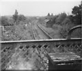
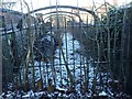
Hazelwell Station
View looking north-east from former footbridge across station at Cartland Road. The buildings on south platform have since been demolished. Some elements of buildings at road level still remained in commercial use.
Image: © Michael Westley
Taken: Unknown
0.18 miles
4
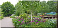
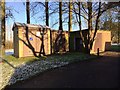
Television Garden, Kings Heath Park
A fenced off area of Kings Heath Park was used to make gardening shows for TV. It has also been used for horticulture students and is sometimes open to the public. See https://www.birmingham.gov.uk/info/20089/parks/1679/kings_heath_park/5
Image: © Paul Collins
Taken: 10 May 2020
0.19 miles
5
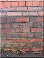
OS benchmark - King's Heath, Cartland Road railway bridge
An OS cutmark on the brickwork of the railway bridge on Cartland Road; levelled in 1965 at 152.254m above Ordnance Datum Newlyn.
Image: © Richard Law
Taken: 16 Dec 2019
0.19 miles
7
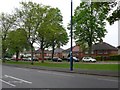
Cartland Road
Several suburban roads in south Birmingham were originally laid out in the 1930s as boulevards with enough space for a dual carriageway. Cartland Road is one of them. It links Vicarage Road (the A4040) with the Pershore Road (the A441).
Image: © Nigel Mykura
Taken: 24 Apr 2011
0.20 miles
9
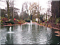
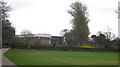
Ornamental pond in King's Heath Park
The building in the distance is King's Heath House. This was built in the 1830s. In the early 1900s the house and its 30 acre estate was transferred to Birmingham Corporation. In 1952 the house became a horticultural training college.
Image: © Phil Champion
Taken: 19 Feb 2006
0.21 miles