IMAGES TAKEN NEAR TO
Newlands Road, BIRMINGHAM, B30 2RG
Introduction
This page details the photographs taken nearby to Newlands Road, B30 2RG by members of the Geograph project.
The Geograph project started in 2005 with the aim of publishing, organising and preserving representative images for every square kilometre of Great Britain, Ireland and the Isle of Man.

There are currently over 7.5m images from over14,400 individuals and you can help contribute to the project by visiting https://www.geograph.org.uk
Image Map
Images are licensed for reuse under creativecommons.org/licenses/by-sa/2.0
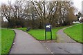
Notes
- Clicking on the map will re-center to the selected point.
- The higher the marker number, the further away the image location is from the centre of the postcode.
Image Listing (59 Images Found)
Images are licensed for reuse under creativecommons.org/licenses/by-sa/2.0
Image
Details
Distance
1

Newlands Road, looking north-northeast, Stirchley, Birmingham
A residential road which in the far distance ends at a T-junction with Cartland Road.
Image
Image: © P L Chadwick
Taken: 3 Jan 2017
0.01 miles
2
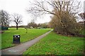
Footpath and waste bin, Hazelwell Park, Stirchley, Birmingham
This footpath leads into the park from Newlands Road. In the far distance is Hazelwell Play Area for children.
Image: © P L Chadwick
Taken: 3 Jan 2017
0.04 miles
3
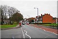
Cartland Road, Stirchley, Birmingham
A mainly residential road. The road coming in on the left is River Brook Drive. The Queen Elizabeth II postbox can be seen in a closer view here:- Image
Image: © P L Chadwick
Taken: 3 Jan 2017
0.04 miles
4
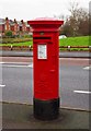
Elizabeth II postbox, Cartland Road, Stirchley, Birmingham
Located by the corner of Cartland Road and River Brook Drive. In the background, on the other side of the road, is part of Hazelwell Park.
Postbox number:- B30 975. Post code:- B30 2**. Last collection:- 4.30 pm Monday to Friday; 11.30 am Saturday. The box can also be seen in this view of Cartland Road:- Image
Image: © P L Chadwick
Taken: 3 Jan 2017
0.05 miles
5

Cartland Road entrance to Hazelwell Park, Stirchley, Birmingham
The footpath, which is also a cycleway, runs the length of the park and forms part of the Rea Valley Cycle Route.
Image: © P L Chadwick
Taken: 3 Jan 2017
0.06 miles
6

Newlands Road, looking east-southeast, Stirchley, Birmingham
This part of Newlands Road consists mainly of terraced housing. There are no garages so cars have to be parked on the street.
Image
Image: © P L Chadwick
Taken: 3 Jan 2017
0.06 miles
7
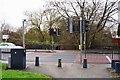
Pedestrian crossing, Cartland Road, Stirchley, Birmingham
Pedestrian crossing controlled by lights in this busy road.
Image: © P L Chadwick
Taken: 3 Jan 2017
0.07 miles
8
Footpath junction, Hazelwell Park, Stirchley, Birmingham
The footpath and cycleway on the left is part of the Rea Valley Cycle Route and after leaving the park crosses Cartland Road. The path on the right goes up to Newlands Road.
Image: © P L Chadwick
Taken: 3 Jan 2017
0.07 miles
9
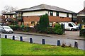
River Brook Medical Centre, 3 River Brook Drive, Stirchley, Birmingham
According to its website, this GP medical practice was originally in Pershore Road Stirchley. In 1987 it relocated to the present site. It was redeveloped in 2002 and during the last 10 years has doubled in size.
Image: © P L Chadwick
Taken: 3 Jan 2017
0.08 miles
10
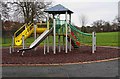
Children's slides, Hazelwell Play Area, Hazelwell Park, Stirchley, Birmingham
The Play Area is in Hazelwell Park, adjacent to the Rea Valley Cycle Route.
Image: © P L Chadwick
Taken: 3 Jan 2017
0.08 miles