IMAGES TAKEN NEAR TO
Sparrey Drive, BIRMINGHAM, B30 2LX
Introduction
This page details the photographs taken nearby to Sparrey Drive, B30 2LX by members of the Geograph project.
The Geograph project started in 2005 with the aim of publishing, organising and preserving representative images for every square kilometre of Great Britain, Ireland and the Isle of Man.

There are currently over 7.5m images from over14,400 individuals and you can help contribute to the project by visiting https://www.geograph.org.uk
Image Map
Images are licensed for reuse under creativecommons.org/licenses/by-sa/2.0
Notes
- Clicking on the map will re-center to the selected point.
- The higher the marker number, the further away the image location is from the centre of the postcode.
Image Listing (102 Images Found)
Images are licensed for reuse under creativecommons.org/licenses/by-sa/2.0
Image
Details
Distance
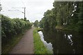
1
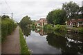
Worcester & Birmingham Canal towards bridge #77B
Image: © Ian S
Taken: 20 Aug 2021
0.04 miles
2
Flying the flag on Sparrey Drive
Seen from a passing narrowboat on the Worcester & Birmingham Canal.
Image: © Christine Johnstone
Taken: 4 Sep 2012
0.04 miles
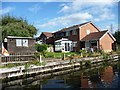
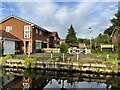
3
Modern house beside the Worcester and Birmingham Canal
This canalside property is in Sparrey Drive.
Image: © David Martin
Taken: 7 Aug 2022
0.04 miles
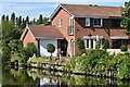
4
Houses on Sparrey Drive
With GWR themed additions.
Image: © Andrew Abbott
Taken: 13 Sep 2022
0.04 miles
5
Worcester & Birmingham Canal towards bridge #77B
Image: © Ian S
Taken: 20 Aug 2021
0.07 miles
6
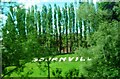
Bournville from railway line
Viewed towards Cadbury World from northbound railway line to north of Bournville Railway Station
Image: © Clint Mann
Taken: 8 Jun 2015
0.08 miles
7
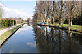
Worcester and Birmingham Canal at Bournville
Poplar trees reflected in the Worcester and Birmingham Canal at Bournville.
Image: © Philip Halling
Taken: 20 Apr 2013
0.08 miles
8
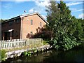
Fig tree growing on the canal bank
Alongside homes in Lea Yield Close.
Image: © Christine Johnstone
Taken: 4 Sep 2012
0.08 miles
9
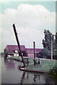
Former Cadbury's Wharf on East side of canal - June 1970
The buildings in the background are sheds overhanging the East side of the canal where narrowboats were unloaded with materials they were conveying on behalf of Cadbury's Bournville Factory - this was on the opposite (West) side of the canal and adjacent railway line so they could not unload directly into the factory. At some point between 1920 and 1928 Cadbury's constructed this wharf and extended their rail system over the mainline and canal (see Image and others for the bridge) to link the new facility directly to the factory. The date comes from photos on the "Britain from Above" website.
By the date of this photo the wharf was no longer in use.
I assume the 'drawbridge' was to allow Cadbury employees to cross the canal to get and from the factory in a short-cut via the canal towpath on the West side of the canal.
(Photo is a scan from an Agfa 35mm colour slide and has been corrected for a colour cast in 'Photoshop'.)
Image: © John Webb
Taken: Unknown
0.09 miles
10
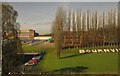
Bournville
A similar photo to Image, with spring growth beginning to obscure Laburnum House on the right (occupied by Serco), and part of the Cadbury's factory on the left.
Image: © Derek Harper
Taken: 6 Apr 2012
0.09 miles