IMAGES TAKEN NEAR TO
Midland Road, BIRMINGHAM, B30 2EY
Introduction
This page details the photographs taken nearby to Midland Road, B30 2EY by members of the Geograph project.
The Geograph project started in 2005 with the aim of publishing, organising and preserving representative images for every square kilometre of Great Britain, Ireland and the Isle of Man.

There are currently over 7.5m images from over14,400 individuals and you can help contribute to the project by visiting https://www.geograph.org.uk
Image Map
Images are licensed for reuse under creativecommons.org/licenses/by-sa/2.0
Notes
- Clicking on the map will re-center to the selected point.
- The higher the marker number, the further away the image location is from the centre of the postcode.
Image Listing (19 Images Found)
Images are licensed for reuse under creativecommons.org/licenses/by-sa/2.0
Image
Details
Distance
1
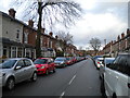
Rowheath Road, Cotteridge
Seen from near the junction with Watford Road.
Image: © Richard Vince
Taken: 10 Mar 2018
0.13 miles
3
East end of Northfield Road, Cotteridge
Seen from Watford Road.
Image: © Richard Vince
Taken: 10 Mar 2018
0.15 miles
4
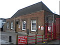
Royal Mail Kings Norton Delivery Office, Watford Road, Cotteridge
Like the railway station, this delivery office is actually in Cotteridge but takes its name from the rather more upmarket area a little way south.
Image: © Richard Vince
Taken: 10 Mar 2018
0.16 miles
5
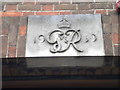
Royal Mail Kings Norton Delivery Office, Watford Road, Cotteridge (detail)
The stone above the front door, indicating a build date of 1939 in the reign of King George VI.
Image: © Richard Vince
Taken: 10 Mar 2018
0.16 miles
6
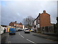
Holly Road, Cotteridge
Off Pershore Road.
Image: © Richard Vince
Taken: 10 Mar 2018
0.19 miles
7
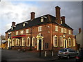
The Grant Arms, Cotteridge
On Pershore Road just east of Cotteridge centre.
Image: © Richard Vince
Taken: 10 Mar 2018
0.19 miles
8
Watford Road, Cotteridge, 1993
The outer ring road [Watford Rd] at Cotteridge, Birmingham in 1993
Image: © Rob Newman
Taken: Unknown
0.20 miles
9
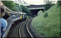
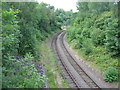
Rounding Lifford Curve
Class 50, 50031, takes Lifford Curve with the Southern Electric Group's 'Walsall Concerto' railtour. The curve connects the Water Orton - Longbridge line with the Bournville and Selly Oak line into Birmingham New Street. The bridge carries the A441 Pershore Road over the railway.
Image: © Martin Addison
Taken: 27 Jun 1987
0.20 miles
10
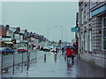
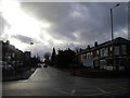
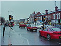
Pershore Rd, Cotteridge, 1993
Pershore Road at Cotteridge, Birmingham, looking towards the city in 1993
Image: © Rob Newman
Taken: Unknown
0.21 miles